
The Ultimate Snoqualmie Falls Guide
Nestled just 30-minute or so drive from the hustle and bustle of downtown Seattle in the beautiful Snoqualmie…
Disclosure: This post contains affiliate links. If you make a purchase through these links, I may earn a small commission at no additional cost to you. I only recommend products or services that I believe will add value to my readers.
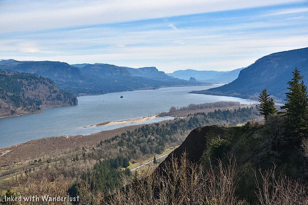
Nestled just a thirty minute drive from the hustle and bustle of Seattle in the beautiful Snoqualmie Mountains is one of Washington State’s most popular attractions, the 270-foot tall, Snoqualmie Falls.
While the falls have always been an amazing sight to see, an explosion of popularity occurred in the early 1990’s when the waterfall was prominently featured in the hit TV series “Twin Peaks”. It now brings in 1.5-million visitors, annually.
No visit to the area would be complete without at least making a quick stop to view it from the upper deck. Whether you spend ten minutes or two hours, coming out is worth the effort.
So whether you're looking for great day trips from Seattle or you want to spend a day away from the city, this guide has you covered. Let’s get into it.
Getting to Snoqualmie Falls

If you’re like most people, you’ll be coming to the falls from Seattle. It’s a fairly straight forward drive from the city to the upper plaza, making it the perfect day trip.
The exact milage will vary depending on where you’re starting from generally, it's a bit more than thirty minutes, one-way, with only a few turns.
From Seattle, the directions are as follows:
Look for signs pointing you to I-5 South and get on it.
Follow the signs to the I-90 East turn off and stay on it.
Take exit #25 toward Snoqualmie Pkwy and turn left on WA-18E
Turn left on Railroad Ave then stay on Railroad Ave after the traffic circle (3rd exit)
Shortly after, you’ll see the entrance for the falls on your left.
Parking at Snoqualmie Falls

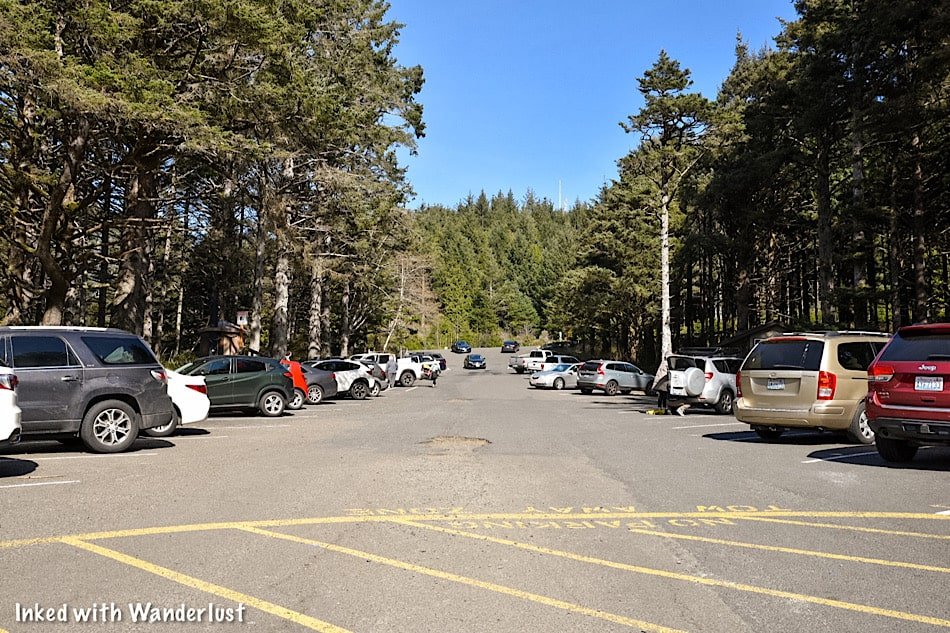
You’ll have two options for parking and they’re both incredibly easy:
Option #1 would be the main lot right off the rim. It’s large enough to accommodate many vehicles but since it’s closest to the falls, there’s a fee. It’s $7 for a two hour period and $5 for each additional hour. The fee can be paid at the self-serve kiosks near the Visitor Center (you will need to know your license plate number).
Option #2 is the larger parking lot across the road that connects to the park via an overhead bridge. This lot can accommodate many more vehicles and is free. It’s also ADA accessible. So if the main lot is full, fret not. Just head across the street.
The recently renovated Visitor Center and Gift Shop are fully open to the public. It includes new exhibits, restrooms and an ice cream shop. Their hours are as follows:
Monday - Friday: 10am - 4pm
Saturday & Sunday: 9am - 4pm
Snoqualmie Falls Upper Viewing Deck

If you type “Snoqualmie Falls” into your phone’s GPS, it’ll likely take you the parking lot at the Upper Plaza. It’s the most visited area of the park as it provides that classic view of the falls from the rim.
Here is where you’ll see an exhibit of an old, used turbine. These are used in conjunction with the force of the falls to generate energy for the surrounding area.
We’ll go over this further into the post as it’s the Lower Plaza where you’ll see a grandeur example of this at work.

To the right of the turbine is where you’ll find the beginning of the trail that leads to another viewpoint and to the Lower Plaza below.
This trail is less than half a mile but you will drop you nearly 300 feet. While it’s fairly easy going down, coming back up will be challenging, unless you’re in decent shape.
Before descending the trail, there’s another viewpoint worth checking out. This is called the, “Peregrine Viewpoint”. Named after the birds who inhabit this area. It’s a little further down and it’s a slightly more straight-on view of the falls.
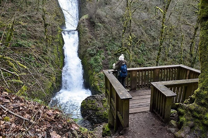
Lower Park Plaza

The Lower Plaza is not as well known. It is here where you’ll get the “down below” view, access to the Snoqualmie River and see the energy producing turbines up close and personal.
You have two options to get the lower plaza from above:
As stated above, you can hike the roughly half mile trail. It’ll take you straight to it but you will have a jaunt going back up. It’s not advisable if you’re not in decent shape and/or don’t have the proper footwear.
Your other (much easier) option would be to drive to it. Turn left out of the main lot or right out of the free lot and head down the road for a few miles. You’ll turn left on Fish Hatchery road and follow that until it terminates at the lower plaza parking lot.

You’ll find the trail leading to the lower viewing deck to the right of the visitor center. Before reaching the boardwalk, you’ll see further examples of turbines and other process equipment with literature explaining how they were used.
Past here, you'll head down a series of stairs and onto a scenic boardwalk with the roaring Snoqualmie River on one side and beautiful moss covered trees on the other. This short journey to the deck is worth the visit all its own.
I didn’t check the exact amount of time it took to reach the deck from the parking lot but including stops to check out the turbines and take photos, it probably took me less than 10 minutes.


The deck is fairly small and can comfortably fit a dozen or so people at a time. Keep this in mind if you’re visiting on a particularly busy day.
The view of the falls from the deck is unique compared to the top. In my opinion, it’s superior to the rim view, as you get the river and surrounding greenery creating a magical scene.
Once you’ve gotten your fill of the views and took your pictures, simply turn around and head back the same way you came in.
Best Time to Go

That’s relative to your personal tastes. Most will tell you spring is the best time due to the fresh run-off from the mountains. If your goal is to see Snoqualmie at its fullest, spring would be the time.
I was here in early March (not quite spring). The runoff was decent and there were no crowds to deal with. Weather wise, the warmth of summer would be the way to go, but it’ll be the most crowded.
Late September and October will bring beautiful fall foliage to complement the scenery around the falls. Winter, while easily the least crowded of any season, brings cold weather with possible snow and ice.
My personal recommendation would the months of eMarch or April. Chances of snow and ice are minimal, as are the crowds. The runoff, in my experience, is good but your results may vary. It was a bit chilly during my visit, but the lack of crowds made it worthwhile.
Nearby Attractions

While making the trip from Seattle to Snoqualmie to see the falls is more than worth the effort, it isn’t exactly an all-day outing.
We were able to see the falls and what it had to offer in a couple hours. Since you’re heading out there anyway, may as well see what else Snoqualmie has to offer.
Hiking Trails

There are many hiking trails in the area. The most popular being Rattlesnake Ledge. The trailhead is located about 10 minutes from the falls in Snoqualmie Point Park and while it requires some effort to complete, it’s short and sweet with an epic payoff. Check out AllTrails for more information on that.
Historic Train Museum

Located on the side of the road heading into downtown Snoqualmie is a line of preserved, historic trains, free for public viewing.
There’s an easy, paved trail that runs alongside all of them and makes for an excellent outing for families with small children.
Local Shops & Restaurants

Along the main road that cuts through town you can find many local shops and eateries to dine at. Supporting local businesses, especially now, is a great way to complete the experience. My personal favorite, Caadxi Oaxaca, serves up amazing spicy pork and fish tacos
Lodging
If you’re keen on staying in the area, you have a few options. You have your standard chain options such as Holiday Inn and SpringHill.
If you’re a Marriott Bonvoy member, you have a couple options in nearby Redmond and Bellevue. The best option, however, would be the Salish Lodge and Spa. It overlooks the falls at the rim and is an utterly beautiful property.


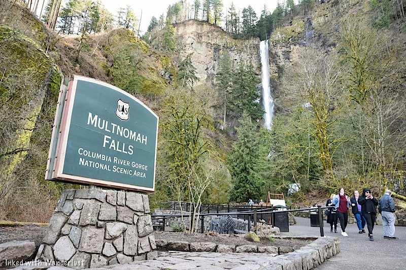
The Ultimate Multnomah Falls Guide
At 611-feet (between the upper and lower portions), Multnomah Falls is the tallest waterfall in Oregon and the crown jewel…
Disclosure: This post contains affiliate links. If you make a purchase through these links, I may earn a small commission at no additional cost to you. I only recommend products or services that I believe will add value to my readers.
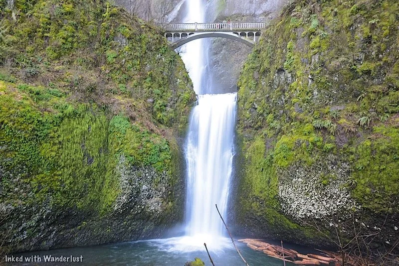
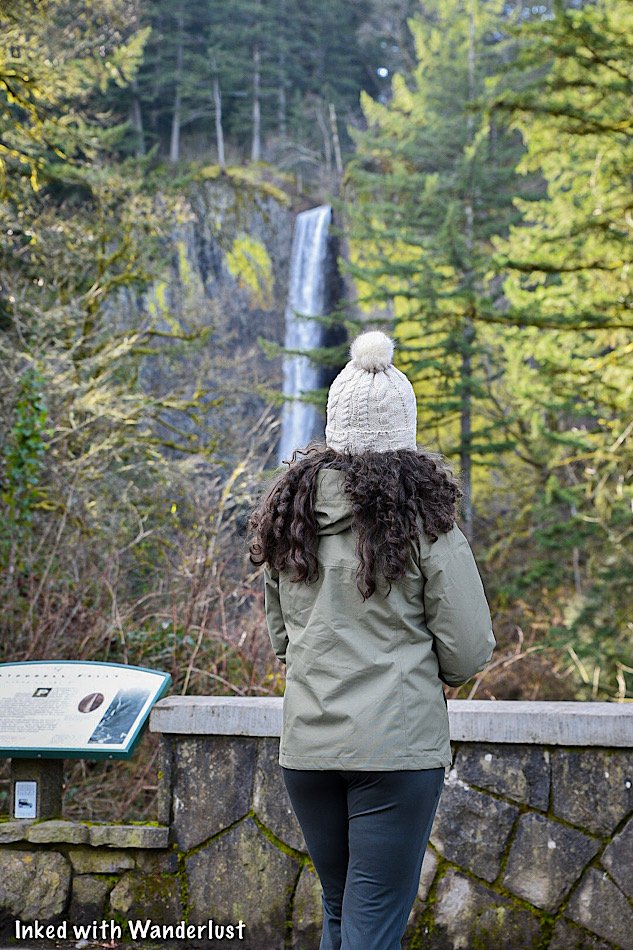
At 611-feet (between the upper and lower portions), Multnomah Falls is the tallest waterfall in Oregon and the crown jewel of the state.
It’s been on our bucket list for quite some time and recently, we were fortunate enough to finally see it for ourselves. Let me tell ya, it was every bit as epic as we were expecting.
We discovered, however, that depending what time of year you go, it isn’t as simple as just, ‘showing up’. You will have a few things to iron out before going.
So what do you need to know before going? Will you need a permit? Is there an admission fee? How do you get there? We cover all of that and more below. (Updated for 2025.)
*A big fire ripped through this area a few years ago and severely damaged many trails. Some have been repaired and reopened, but others remain closed. For up-to-date information on trail closures and what’s open, refer to the website, “Ready Set Gorge”.
*Multnomah Falls, including its trails, are open to the public.
Directions To Multnomah Falls
Multnomah Falls is easy to get to and is conveniently located right off of the Columbia Gorge Historic Scenic Byway.
The nearest town to it is Troutdale, Oregon, but it isn’t far from major cities like Portland and Vancouver. In fact, it’s only a 30-minute(ish) drive from either.
Distance to Multnomah Falls
From downtown Portland: 32 miles or a 35 minute drive
From Portland Airport: 26 miles or a 30 minute drive
From downtown Vancouver: 34 miles or a 40 minute drive
From Salem, Oregon: 75 miles or a 1 hour and 20 minute drive
From Eugene, Oregon: 140 miles or a 2 hour and 15 minute drive
It’s one of the most visited natural sites in the Pacific Northwest, so road signage is plentiful. Plugging in, ‘Multnomah Falls”, into your GPS of choice will get you there easily.
What we suggest you do, especially if you’re coming from Portland, is to start at Vista House and then work your way from waterfall to waterfall along the Historic Columbia River Highway.
Multnomah Falls Parking

There are two parking lots at Multnomah Falls. The closest is the small one directly across the street from the lodge along the historic highway. By our estimate, it can hold around fifty vehicles.
If you’re able to snag a spot here (like we did), it’ll grant you the fastest and most convenient access to the falls. Just cross the street and you’re there. In addition, you won’t need a parking permit.
It’s a small lot, though. We were here in March, arrived early, and got the second to last available spot. In the summer months, it can and does fill quickly.
The larger lot is right off of I-84 via exit 31. A walking path leads you from the lot, under the highway and to the crosswalk. There’s no fee during the off-season. However, between May and September, you’ll need a timed use permit (more on that below).
Multnomah Falls Timed-Use Permits
During the summer months, you will need a timed reservation in order to park at the I-84 lot (exit 31). In 2024, the official timeframe is May 26th - September 4th.
*Note: There hasn’t been an announcement as of yet pertaining to timed reservations for 2025. However, considering the program’s success over the prior two seasons, I expect more of the same for 2025.
Timed reservations are made through Recreation.gov and there are two options to consider:
Option One: Timed reservations become available 14-days from your desired date, starting at 7am PST, on a rolling daily period. For example, if your desired date is August 15th, reservations become available August 1st. at 7am PST.
Option Two: A certain (unspecified) amount of timed reservation permits will be available for same-day, in person pick up at the Gateway to the Gorge Visitor Center in Troutdale and at the Cascade Locks Historical Museum.
The fee for a reservation is $2.00, per permit. You’ll only need one permit, per vehicle. This is NOT a per person charge. If you arrive early enough and find parking at the small lot along the historic highway, a timed use permit is NOT required.
In 2022, Oregon officials decided to restrict access to the historic highway (waterfall corridor) between Bridal Veil Falls and just past Multnomah Falls via a timed use permit during the summer months.
For 2023 (and presumably beyond), they’ve decided to contain the permit requirement to just the I-84 parking lot for Multnomah Falls. You will NOT need an additional permit to access the waterfall corridor.
Some other things you’ll need to know:
You must arrive at the time stated on your reservation. You’ll be given a one-hour grace period. After that, your reservation becomes invalid.
You can show either a printed copy or the digital version (preferred).
Drop-offs in front of the Lodge will not be allowed.
Once you’re there, you can stay for as long as you like.
Timed reservations are NOT required if you arrive via shuttle, bicycle, or tour.
Shuttle Service To Multnomah Falls
Taking a shuttle to Multnomah Falls is an excellent alternative to driving and dealing with the traffic congestion.
There are numerous operators, each with their own fees, operation schedules, and pick-up locations. All, however, offer hop-on/hop-off privileges at all the main sites.
These include:
Multnomah Falls
Crown Point (Vista House)
Latourell Falls
Bridal Veil Falls
Wahkeena Falls
Horsetail Falls
And more!
Fares vary, but between the three that we’ve found, it seems to be a range of $15 - $21, per adult. Some include one child in the price.
Here are the shuttle operators. Tap or click the name to go to their website:
The cost of shuttles are way more than the reservation fee for sure, but the advantages of not having to worry about getting one at all or dealing with parking may be worth it to you.
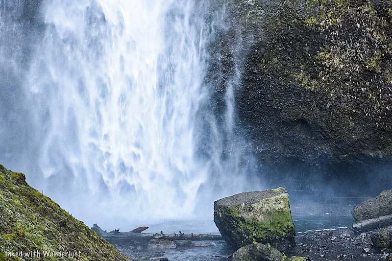
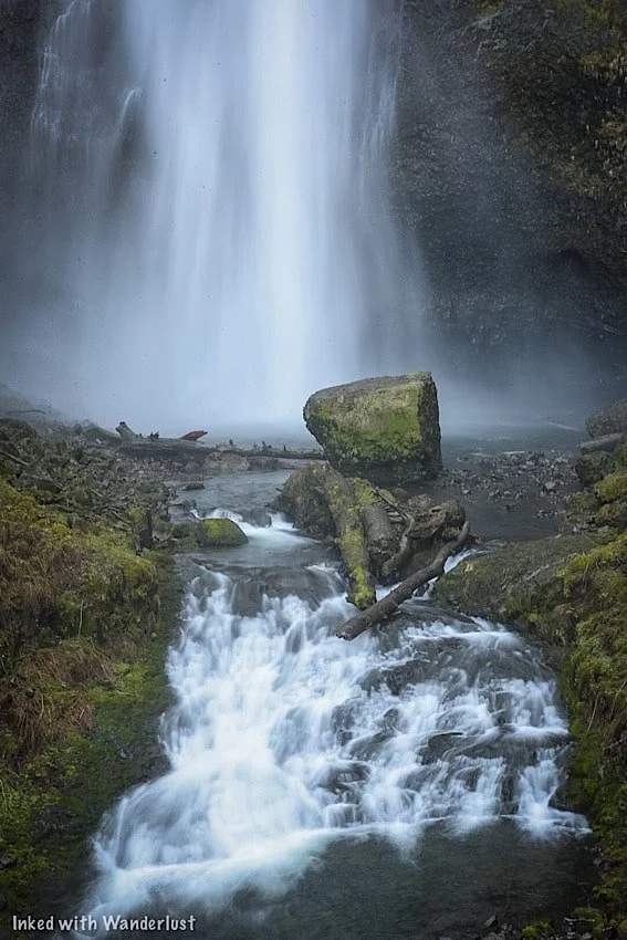
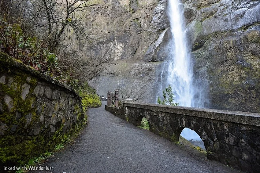
Lower Viewing Deck

The main viewing deck is in front of the lower section of the falls. It’s the easy to get to as it’s just to the left of Multnomah Falls Lodge.
There’s a ramp to the right of the stairwell enabling access for wheelchairs and strollers. You can enter the ramp near the lodge’s snack bar.
It’s where most people view and photograph the falls from and is open year round. Even on a busy day, there’s plenty of elbow room.
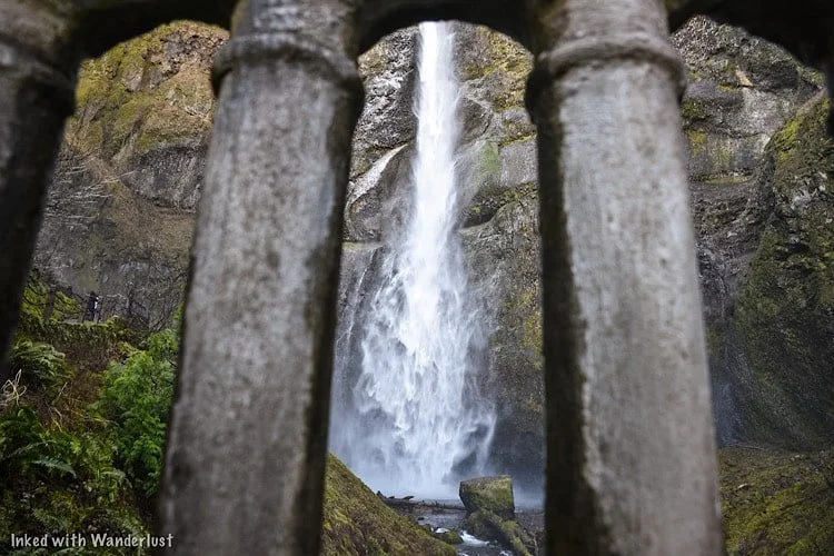
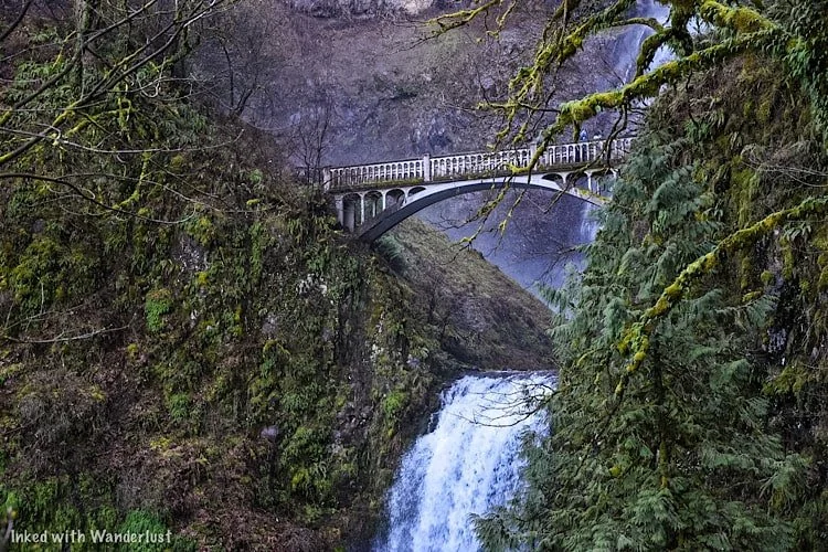
Benson Bridge
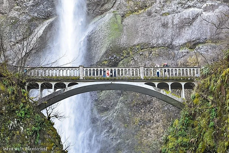
The footbridge is a unique feature of Multnomah Falls. It is named after a man named Simon Benson, who is the person responsible for the bridge’s conception.
It was built in 1914 and is made of reinforced concrete. It spans across Multnomah Creek, between the waterfall’s two cascades, 105-feet above the base of the lower fall.
It provides unparalleled views of the upper section and connects visitors to the trail leading to the top of Multnomah.
To access the bridge, you’ll see an iron gate to the side at the lower viewing deck. Go through the gate and continue up the Larch Mountain trail.
*During winter, the bridge is known to freeze over. If this occurs, that gate will be closed and visitors are not allowed past that point.
From the lower viewing deck, it’s a 2/10’s of a mile, steadily uphill walk to the bridge. It is paved and the falls are within view nearly the entire route.
Hiking Trails To The Top & Beyond
If you’re feeling up to it, you can continue for another 8/10’s of a mile (one-mile from the bottom) to the top of Multnomah Falls.
You’ll be going up switchbacks the entire way and there’s a small viewing deck at the end overlooking the top of the falls.
We decided against this as the bridge was fairly iced over and we were told by others coming back down that the trail itself was worse.
If it’s warmer while you’re here, we definitely recommend going up there. We’ll be doing it on our next visit for sure.
There are two other destinations you can reach from this trail. They are:
Wahkeena Falls: Via the Wahkeena Trail portion, you’ll continue past the upper deck of Multnomah Falls and will eventually reach Wahkeena Falls, passing multiple other waterfalls along the way. Total milage from the bottom is 1.8-miles.
Larch Mountain: For those looking for a challenge, hike up to Larch Mountain. Based on the pictures we’ve seen, the views are spectacular. Total milage from the bottom is 6.8-miles.
SEE MY TOP RECOMMENDATION FOR A DAY HIKE BACKPACK ON AMAZON HERE!
Multnomah Falls Lodge

Multnomah Falls Lodge is an authorized concessioner providing many amenities to visitors. It features a gift shop, restroom, restaurant, and espresso bar.
If you want to dine here, specifically in the summer months, reservations are highly ecouraged. If you want to check out their menu, go here.
If you’re like us and visit during the off-season, you shouldn’t have a problem getting a table. We walked in and we’re seated right away.
The service was great, we were seated at a table with a great view of Multnomah, the beer was cold, and the food was good.
Nearby Lodging
Despite the name suggesting so, Multnomah Falls Lodge doesn’t have a hotel attached to it.
If you’ll be spending the majority of your vacation in the Columbia River Gorge, here are a few hotels located nearby:
Columbia Gorge Hotel: In Hood River, Oregon, 25-miles east
Best Western Columbia Inn: In Cascade Locks, Oregon, 11-miles east
Edgefield Manor: In Troutdale, Oregon, 18-miles west
So where should you stay? That’s dependent on your preferences, plans, and budget. If you’re coming strictly for the gorge, we would recommend staying in Troutdale or Cascade Locks.
If you plan to visit Portland as well, basing yourself in the downtown area and driving/shuttling into the gorge may make more economic sense.
Weather and Best Time To Go
We visited Multnomah Falls in March of 2022. The weather, while a bit chilly in the morning, was great and we experienced very little in the way of crowds.
If your goal is to see Multnomah at its peak flow and the least amount of visitors possible, we recommend visiting in either winter or mid-spring.
Just keep in mind that due to the mist from the upper fall, Benson Bridge often freezes over and thus, the bridge and trail closes to the public for safety.
In winter, the lower viewing deck could also be frozen over due to snowy conditions.
During our visit, the bridge was partially frozen, but open. We witnessed more than a few people nearly eat concrete (including us) because of it.
If you want to ensure that you can access the bridge, then summer or fall would be the times to go. However, these months come with their own downsides:
Crowds get thick.
Parking can be difficult to come by.
You’ll need a timed reservation to go.
The flow dies off a little bit (winter/spring is the peak).
It’s hot (summer)
If you can stomach the above challenges, then visiting during summer or fall would be the way to go if Benson Bridge is important to you.
For our next visit, we plan to go during the fall. We’ve seen photographs of the fall foliage in the gorge and it is simply stunning.
Additional Information & Reminders
There are no EV charging stations. The nearest ones are in Troutdale, Oregon, west of Multnomah Falls.
Drone use is prohibited. It’s painful, but true. As of January, 2022, the use of drones at Multnomah Falls is prohibited.
Reservations may be required. If your visit coincides with the mid-May to mid-September timeframe, you will need a reservation through recreation.gov.
There are amenities. There’s a clean restroom, gift shop, ATM, snack bar, and restaurant on-site, but no lodging. The closest hotels are in either Troutdale or Cascade Locks.
The bottom platform is handicap accessible. There’s a ramp adjacent to the stairs leading to the bottom platform. All of it is paved. The trail going to bridge, while paved, is not accessible.
Pets are allowed. As long as they’re leashed, you can bring your pet.
Benson Bridge may be closed during your visit. If it freezes over, Benson Bridge closes to the public.

A Quick Note…
We’re often asked about the equipment we use to capture the photos on our website. Below, we’ve added Amazon links to those products and others we recommend.
If you decide to purchase, Amazon will pay us a small commission at no additional cost to you.
“Understanding Exposure” by Bryan Peterson (this book is a great resource for anyone starting out in photography)
“The Landscape Photography Book” by Scott Kelby (another great resource for beginners)

Latourell Falls: A Stunning Waterfall Near Portland Oregon
Of all the waterfalls in the Columbia River Gorge, Latourall Falls, a 224-foot single-plunge fall, is the closest to Portland…
2 minute read | contains affiliate links
Of all the waterfalls in the Columbia River Gorge, Latourall Falls, a 224-foot single-plunge fall, is the closest to Portland.
It’s also your first introduction to what is known as the, “Waterfall Corridor”, a miles-long road featuring an endless amount of waterfalls.
So how do you get to Latourell Falls? How long is the trail? We answer all these questions and more below.

Quick Stats
Location: Guy W. Tolbot State Park (Corbett, OR)
Fee: None
Permit: If you’re here during the summer season, you’ll need a permit to access the waterfall corridor
Open: Year round
For: Hikers
Restroom: In the parking lot
Parking: Large lot at the trailhead
EV Stations: None
Difficulty: Easy
Popularity: High
Trail Type: Loop
Mileage: 0.2 - 2.4 miles (depending how far you take it)
Elevation Gain: Up to 639-feet
Condition: Maintained
Features: Two waterfalls if you complete the loop
Pets: Allowed on leash
Drones: Not permitted
Hazards: During winter or late spring, the trail can be dangerously icy
Our Visit(s): March 2022
Getting There & Parking

If you’re like most people, you’re probably coming from Portland. If so, then plug, “Vista House”, into your phone’s GPS.
Be sure to pull over and spend some time taking in the views of the Columbia River Gorge from here. They’re stunning.
When you’re done, get back on the road and continue going around the Vista House. From there, it’s only 2.5-miles to Latourell Falls.
Shortly after crossing a moss-covered bridge, you’ll see the parking lot on your right. It’s a fairly large lot with restrooms.
Decide Between The Loop or The Base
Latourell Falls can be partially viewed from the handicap accessible viewing deck adjacent to the parking lot.
For the full experience, though, take either the paved, short trail to the base or complete the full loop.
The trail to the base of the falls is just 0.2-miles (or about a 5-minute walk)
The loop trail is 2.4-miles and takes you up and over to another waterfall (Upper Latourell) and then down to the base of Lower Latourell.
If at first you decide to go to the base but later change your mind and want to do the loop, cross the footbridge at the base and continue on.
If you want to begin with the loop, you’ll see the trailhead to the left of the base trail. It’s an immediate climb from the get-go.

We were here in March and it was especially rainy and cold that morning. Due to this, much of the loop was iced over. So we just did the base.
As stated above, the trail to the base of the falls is mostly paved and only takes about 5-minutes.
This portion of the trail ends at a small look-out directly next to the waterfall. It enables you to get very close.


Due to this, expect it to be misty and on top of that, icy if you’re here in winter or early spring.
The area around the falls is like a fairytale with all the moss covered trees. Even the fall’s basalt-rock wall has moss all over it.
To your right, you’ll notice a footbridge crossing over the creek. This is where you’ll continue along the loop if you wanted.


This footbridge can be especially icy in the right conditions. It was when I was there. I almost biffed it a few times trying to take these photos.
If you don’t want to continue onto the loop, simply head back the same way you came to return to your vehicle.

Additional Waterfalls Nearby
Latourell Falls is only the beginning. There are many, many more waterfalls as your progress further down the corridor.
A few of those are:
Bridal Veil Falls: Read about our visit here
Wahkeena Falls: Read about our visit here
Multnomah Falls: The tallest waterfall in Oregon! Read about our experience here
Your Thoughts…
Does Latourell Falls seem like a place you and your family would enjoy?
Let us know in the comments below! We love hearing from our readers.
Please support our website by subscribing to our newsletter below.
Thank you for reading.
Check Out These Amazing California Destinations!


Hug Point Waterfall and Sea Caves: How To Get There, Timing The Tide, and More
Ever wanted to check out a waterfall that feeds directly into the ocean? If you’re near the beautiful coastal town of Canon Beach…
4 minute read | Contains affiliate links
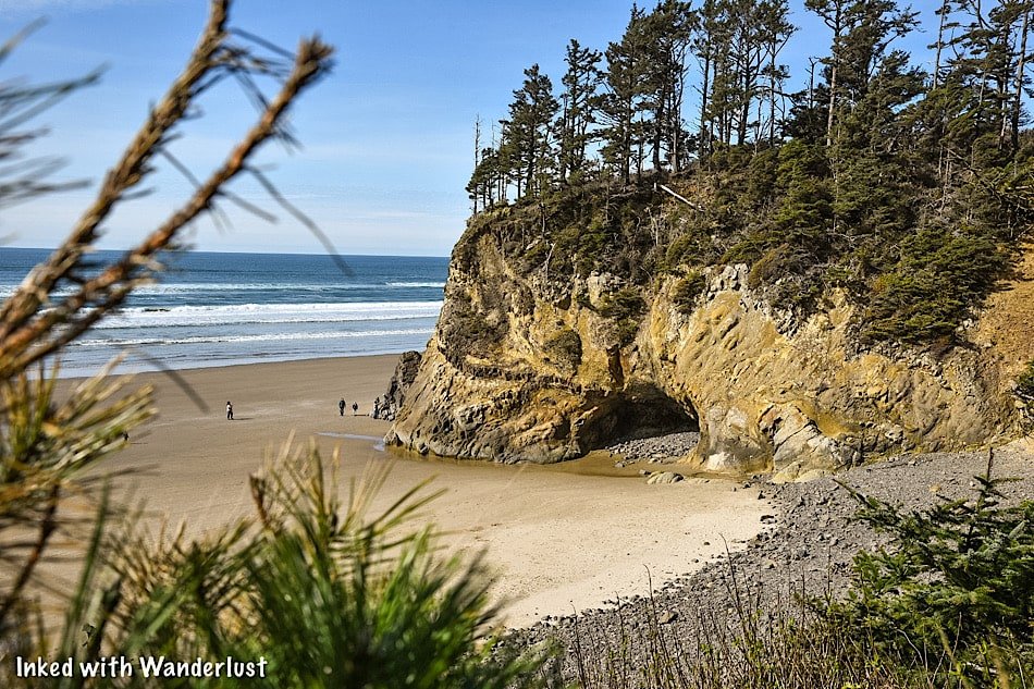
Ever wanted to check out a waterfall that feeds directly into the ocean? If you’re near the beautiful coastal town of Canon Beach, you won’t have to look far.
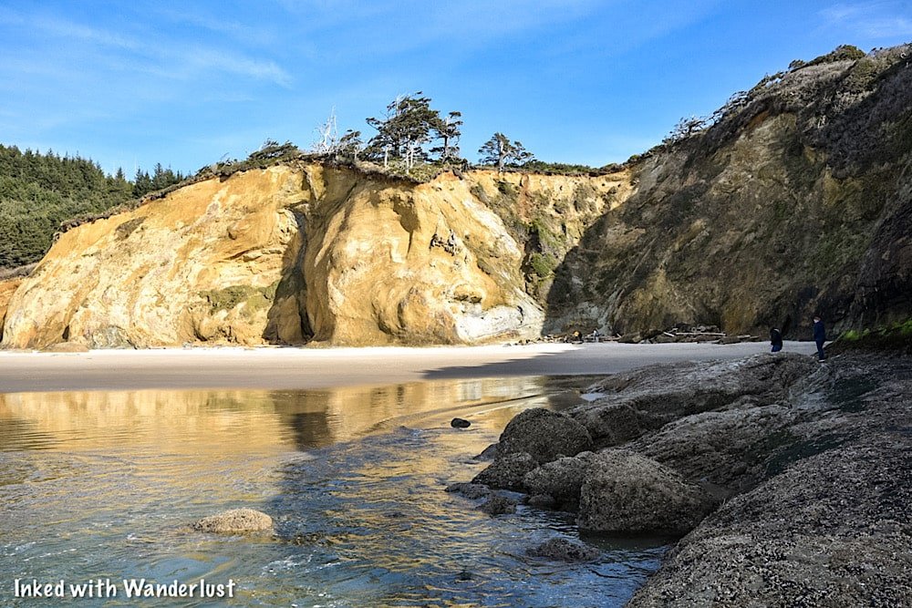
Just four or five miles south on Highway 101 is Hug Point State Recreation Site. This gorgeous 43-acre stretch of Oregon coastline is not to be missed.
The site features the namesake waterfall, a bounty of sea caves carved into rugged sandstone, and jaw-dropping coastal views.

Many people come to Hug Point to see this rare phenomenon for themselves but as some find out, it isn’t as simple as just showing up. You need to know a couple things first.
Thankfully, seeing the waterfall and sea caves is easy as long as you know what you’re doing and are prepared. Things can go south rather quickly otherwise.
In this guide, we’ll provide you with all the necessary information you’ll need to ensure a successful visit (and remain safe at the same time). Let’s get into it!
Here’s some great beach gear we recommend…

Getting Here
The Hug Point waterfall can be found at Hug Point State Recreation Site, just five or so miles from the equally must-see attraction, Haystack Rock.
Getting here from other cities is simple as it’s located along Highway 101. Since it’s a popular spot, any GPS system would easily get you there.
If you’re staying in Portland, it’s an easy day trip. If you brought your own vehicle or can rent one, the drive from downtown to Hug Point is only 83-miles (one-way).

If you don’t have access to a vehicle, there’s a bus that provides twice-daily service from Portland to Canon Beach.
Something you should know, though, is the bus does not service Hug Point directly. It drops off near Haystack Rock’s public parking area in Canon Beach.
So you’ll either need to hitch-hike, walk from Haystack Rock to Hug Point on the beach, or try your luck with ride-sharing options.
Parking
There’s a narrow, but large parking lot at Hug Point that leads straight down to the beach. There are public restrooms and walkways on either side.
We were here in March and arrived at around 1pm. To our surprise, we had no issue getting a parking spot. If you’re here in the summer, though, plan to arrive early.
There were, “no parking”, signs all along the road outside the lot so if it’s full, you may have to circle around a few times until a spot opens up.

As you make your way to the stairs leading to the beach, keep an eye out for a lookout point on your right. There’s a small, short spur trail that’ll lead you to it.
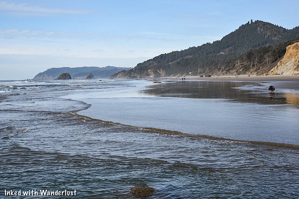
This view gives you a great idea of how inaccessible Hug Point is during high tide; as you can easily see the wave lines up to the rocks.
Hug Point Tide Times
Before we get to the waterfall, we want to reiterate the importance of checking the tide before you go, as the waterfall is 100% inaccessible during high tide.
Timing low tide is important, but knowing when high tide comes back in is even more so. You do NOT want to get stuck out there.
To check tide times by specific dates, check this website. Be sure to bookmark it and check again before your visit.

Hug Point Waterfall
From the stairs leading to the beach, getting to the waterfall is simple and straight forward. Simply go north (right) from the stairs, towards the large sea cliff ahead.
You’ll go around the sea cliff at the point (the side closest to the water) and continue straight. As you get around it, you’ll see the waterfall about 200 yards out.


When Hug Point waterfall came into view, I was floored by the amazing scenery. Even though it wasn’t at peak flow (more on that later).

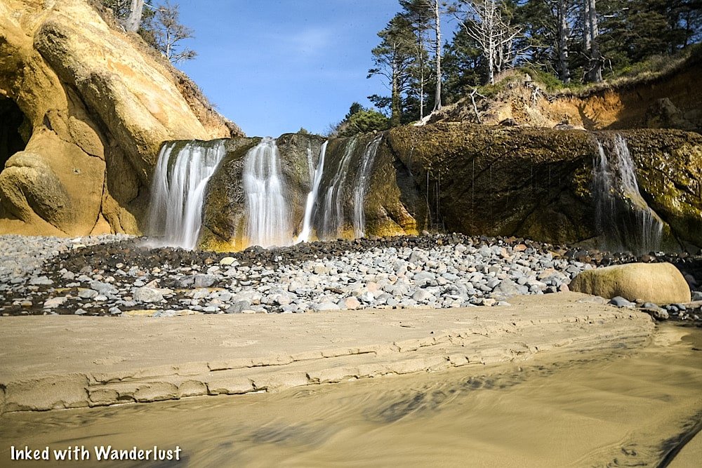


In case you’re wondering, yes, you can climb up to the top of the falls. There isn’t much to see and the rocks on the way up are slick, but you’re ok to go up.
Facing the beach from the top provides a unique perspective that most don’t see (most people look at the waterfall and move on).
Just know that at peak flow, it may be too dangerous to go up to the top. Just use common sense and you should be fine.


The beach in front of the waterfall makes for a great spot for a family picnic or recreating. During our visit people were flying kites, picnicing, etc.
Just around the way from the waterfall are a handful of caves carved into the limestone by waves over thousands of years.
Definitely check these out but as stated above, be mindful of high tide. Getting stuck in one of those caves wouldn’t end well.
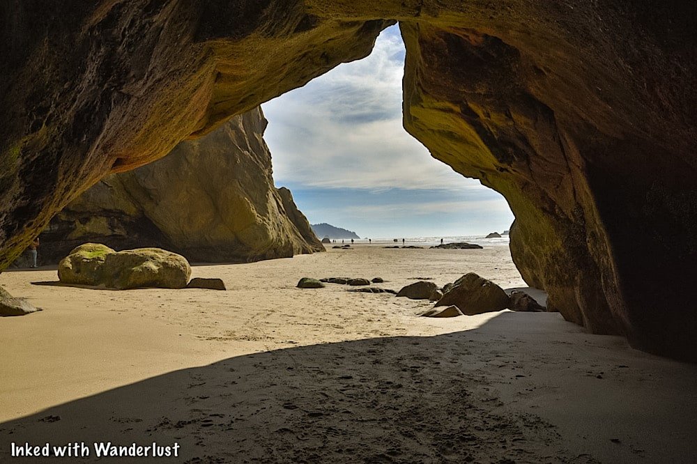
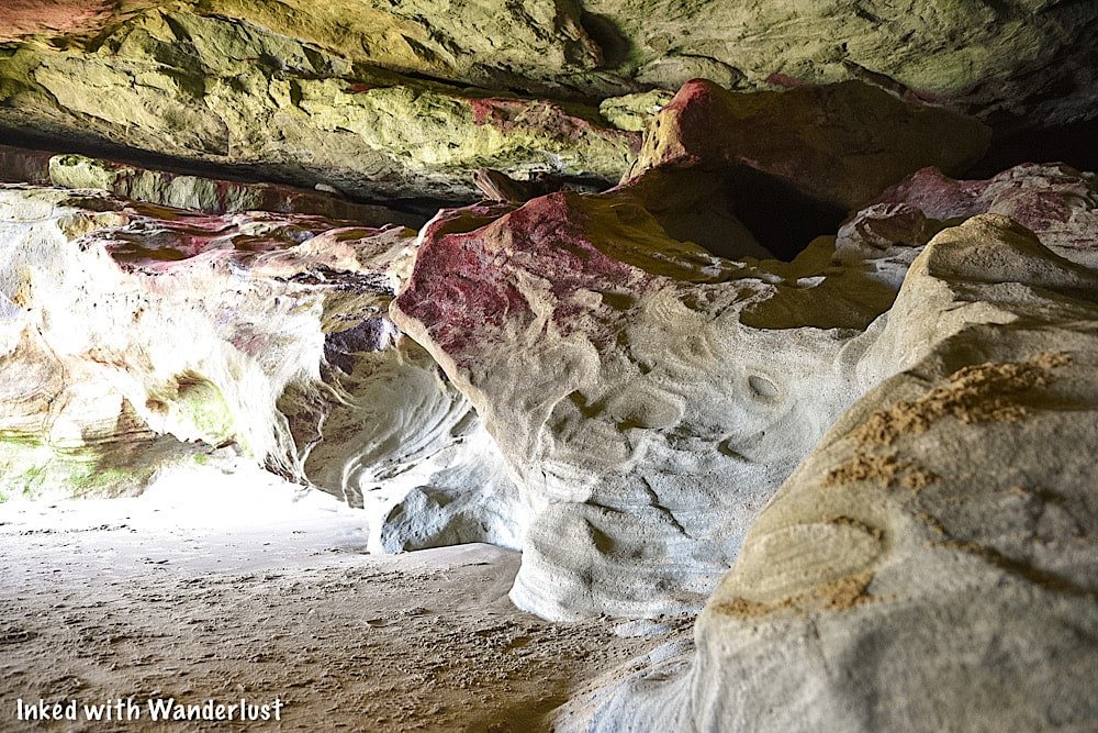
The largest one we had found is at the back of the cliffs and has multi-colored patterns on the limestone. You can see, in great detail, the pattern of the waves in the rock.
When we got around to the other side, though, it was pitch black and the flashlight on our phones didn’t suffice. So bring a good flashlight if you wish to explore further.

To the left of the caves, you’ll see a shelf that literally “hugs” the cliffside. Take this to go to the other side to another beach and a beautiful enclave.
The shelf is covered with thousands of mussels and unfortunately, you can’t walk here without crushing at least a handful of them.
*Fun Fact: Early Oregon pioneers used this shelf to cross from one end of the beach to the other in stagecoaches.

At the end of the shelf, if you look out into the distance, you’ll see Haystack Rock. If you have the time, you could walk all the way to it from here.

As long as the tide remains low, you can explore all you want. When you’re done, simply head back in the same direction you came.
When To Go
If your main goal is to see the Hug Point waterfall at full flow, then you’ll want to visit in the winter or in very early spring after a healthy rain or snowfall.
When we visited in mid-March, it definitely wasn’t at peak flow. So November - February would probably be your best bet.
There isn’t much rain in the summer so obviously, the later into summer it is, the less flow there will be. Plus, summer is swarming with people.
If you just want to see it and don’t care about how heavy the flow is, then anytime is a good time, really. It just depends on your tolerance for crowds.
A Quick Note…
We’re often asked about the equipment we use to capture the photos on our website. Below, we’ve added Amazon links to those products and others that we recommend.
If you decide to purchase, Amazon will pay us a small commission. This helps us keep Inked with Wanderlust running and doesn’t cost you anything extra.
“Understanding Exposure” by Bryan Peterson (this book is a great resource for anyone starting out in photography)
It is our hope that this article was helpful to you in planning your next adventure. If so, please share it with your family and friends on Facebook or Pinterest.
You can further show support by subscribing to our newsletter below. In it, you’ll receive a once weekly newsletter containing announcements, new post alerts, news, and more!
If you have any questions, comments, or suggestions, please engage with us in the comment section below.
Thanks for reading and safe travels!
A Quick Guide To Visiting The Beautiful Wahkeena Falls (Oregon)
Wahkeena Falls (Wa-Kee-Na) is a multi-tired waterfall along Oregon’s famed, ‘Waterfall Corridor’, in the awe-inspiring Columbia River…
5 minute read | Contains affiliate links
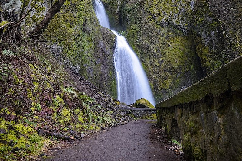
Wahkeena Falls (Wa-Kee-Na) is a multi-tired waterfall along Oregon’s famed, ‘Waterfall Corridor’, in the awe-inspiring Columbia River Gorge.
Named after the Yakama word for, “most beautiful”, Wahkeena Falls has a total height of 242-feet. It may not be as tall as its neighbor, Multnomah Falls, but it’s no less gorgeous.
In this quick guide, we’ll show you a few of the photos we took during our visit and fill you in on some details you’ll want to know before visiting. Let’s do this!
Here’s some great hiking equipment we recommend…
Wahkeena Falls Information

Getting To Wahkeena Falls
Distance from:
Portland: 29 miles east (30 minute drive)
Troutdale: 14 miles east (17 minute drive)
Vista House: 8 miles east (19 minute drive)
Multnomah Falls: 8.5 miles west (15 minute drive)
Cascade Locks: 14 miles west (22 minute drive)
Vancouver: 32 miles west (33 minute drive)
Bend: 162 miles north (3 hour and 15 minute drive)
Coming from Portland or Troutdale, you’ll be on I-84 east for most of the drive. You’ll take exit #28 to Bridal Veil and continue straight on the Historic Columbia River Highway.
From Cascade Locks or further, you’ll travel on I-84 west before taking exit #35 and merge onto the Historic Highway.
If you’re coming from the west, Wahkeena Falls will be after Bridal Veil Falls on your right. If you’re coming from the east, it’ll be after Multnomah Falls on your left.

Parking
Even during the off-season, parking can be scarce at Wahkeena Falls. There’s a small pull-out style lot across the street and an even smaller one in front of the entrance.
When we arrived, both were full. We were here in March, which isn’t a particularly busy time. So in the summer, we can imagine how insane it gets.
If you find yourself in the same situation, do what we did and circle around. This is a spot where most people get out of their car, check it out, and move on.
Chances are good that if you circle around - or even just come back to it later - you’ll snag yourself a spot. Patience will take you far, here.

Hiking At Wahkeena Falls
You can partially view the waterfall from the main viewing deck below, like most people. If you want a great view, though, take the trail up to the footbridge.
While not as famous as Benson Bridge over at Multnomah, Wahkeena Falls has a bridge of its own and yes, you can walk up to it!
Standing in the parking lot and facing Wahkeena Falls, the trail is to your right. If you take the one to your left, you’ll end up at Multnomah.
The trail is part dirt, part gravel and is a 2/10’s of a mile, uphill walk (can’t really designate this as a hike). We would rate the trail as easy for most.

Wahkeena Falls To Fairy Falls
From the footbridge, you can hike a little further up Wahkeena Canyon to another beautiful waterfall, Fairy Falls. It is less than a mile from here.
Due to icy conditions on the trail, we decided to skip it and bank it for our next visit. If you’re here when its warmer, though, you should definitely go for it.
*To see what Fairy Falls looks like, check out the website, The Outbound
Wahkeena Falls To Multnomah Falls Loop
Multnomah Falls and Wahkeena Falls are connected by a network of hiking trails. One of them runs parallel to the Historic Highway between the two waterfalls.
The other trail takes you up to the footbridge, past Fairy Falls, and eventually reaches the top of Multnomah.
From there, drop down to the base of Multnomah Falls and continue left on the trail parallel to the highway, completing the loop.
One-way milage for this hike is 1.8 miles and based on what we’ve been told, the hike is moderate for most. So just use your best judgement.

Is Wahkeena Falls Open?
That’s a question often asked. A big fire ripped through Oregon’s side of the gorge a few years ago and heavily damaged numerous trails and foliage.
To answer your question, yes, Wahkeena Falls IS open. As is the entire loop trail to Multnomah Falls. To get current information on closures, check out the website, Ready Set Gorge.
Weather and Best Time To Go
A lot of this is based on your personal preferences and ability to deal with weather conditions.
Summer: It’s warm/hot with little to no rain. So you won’t have to worry about icy conditions. However, you will be dealing with heavy crowds and needing a permit to access the Historic Highway.
Winter: Crowd levels will be low, but you’ll be dealing with snow and ice conditions. Benson Bridge will be closed for the majority of the season due to it icing over.
Spring: The weather improves, but you’ll be dealing with on and off again rain showers. Mornings are chilly, with ice still present at certain points along the trail. Crowd levels begin to pick up.
Fall: When they peak, fall colors in the gorge are breath taking. Crowds start tapering off from the summer and the weather, while still rainy, is mostly mild.

It is our hope that this article was helpful to you in planning your next adventure. If so, please share it with your family and friends on Facebook or Pinterest.
You can further show support by subscribing to our newsletter below. In it, you’ll receive a once weekly newsletter containing announcements, new post alerts, news, and more!
If you have any questions, comments, or suggestions, please engage with us in the comment section below.
Thanks for reading and safe travels!

Oregon's Waterfall Corridor Permit: Everything You Need To Know To Get One
If you’re planning to visit the many waterfalls, State Parks, and trails along Oregon’s famed, Waterfall Corridor, and you intend…
5 minute read | Contains affiliate links
If you’re planning to visit the many waterfalls, State Parks, and trails along Oregon’s famed, Waterfall Corridor, and you intend to drive, you’re going to need a permit.
The Historic Columbia River Highway (aka, Waterfall Corridor) is a narrow, two lane road that allows visitors easy access to the multiple natural attractions in the area.
The problem is, during the busy summer months, this road has been known to experience heavy traffic congestion. On top of that, parking is nearly impossible to find.
Due to this, the Oregon Department of Transportation decided to implement a vehicle access permit system this year in an effort to reduce the amount of vehicles on the road at a time.
In order to help make your visit go as smoothly as possible, we wrote this comprehensive guide to bring you all the information you’ll need to either get a permit or avoid it all together.
Permit Information

How To Get A Permit, Dates, & Cost
*Official information is a bit scarce at the moment. This article will present current information provided by the Oregon Department of Transportation. As more information gets released, it will be added to this article.
A permit will be required for anyone planning to drive on the Historic Columbia River Highway between May24th and September 5th, 2022, between the hours of 9am and 6pm.
Thus far, no details have been given as to going about obtaining one.
However, considering permits for other area attractions like Multnomah Falls are obtained through Recreation.gov, one could assume that will be case here as well.
As far as cost goes, a representative of the Oregon DOT was quoted as saying, “we anticipate the fee to be around $2”. This will be per vehicle, not per person.
So while not set in stone, the fee is likely to be low and to simply cover the operational costs.
Checkpoint Locations
Per the Oregon DOT, there will be checkpoints at:
Exit #28 near Bridal Veil Falls
Exit #35 near Ainsworth State Park
For context, Bridal Veil Falls is on the west side of this area with Ainsworth State Park being on the east side.
At these checkpoints is where you’ll present your timed permit. You can either show a printed copy or the digital version on your mobile device.
On your permit will be a specific time for you to enter. You will NOT be granted access prior to that time. You can, however, stay for however long you like.
*Also, you will only be able to come through one time. Once you exit through one of the checkpoints, you will NOT be able to re-enter.
*If you accidentally leave, you’ll either need another valid permit or come back after 6pm.

What To Do If You Don’t Have A Permit
The whole point to this program is reduce traffic and its impact on the Gorge. Implementing the permit system allows for the number of vehicles along the highway to be reduced.
To assist in this goal, there are other ways you can visit the Waterfall Corridor without needing to worry about obtaining a permit.
They are:
Taking part in an organized tour
Utilizing one of the various shuttles that service the Gorge.
Park at or near Vista House and use a bicycle to get around.
Arrive by vehicle BEFORE 9am or AFTER 6pm.
One thing to keep in mind that walking along the Historic Highway is not an option. The road is simply too narrow and dangerous for pedestrians.
A few of the notable shuttle companies that service the Gorge are; Sasquatch Shuttle, Columbia Gorge Express, and Explore the Gorge.
*Having a permit only guarantees access. It DOESN’T guarantee parking. It would be wise to at least consider taking a shuttle in.

Attractions Affected (and not affected)
This may be your first time to the beautiful stretch of road and you may not know which attractions are and are not affected by this.
Below is a list of the most popular attractions that you will NOT be able to drive to without obtaining a permit:
Bridal Veil Falls (read our post about this waterfall, here)
Angel’s Rest hiking trail
Wahkeena Falls (read our post about this waterfall, here)
Multnomah Falls (requires a permit of its own)
Oneonta Gorge (currently closed)
Horsetail Falls
Ainsworth State Park
That said, there are multiple attractions you can still visit even if you don’t have a vehicle permit. Some of the most popular ones are:
Portland Women’s Forum State Scenic Viewpoint
Vista House
Latourell Falls
Elowah Falls
Upper McCord Creek Falls
Wahclella Falls
Bridge of the Gods
As you can see, there is still plenty to see. So if you weren’t able to get a permit, spend time at these and then make your way to the others after 6pm.

Multnomah Falls Permit
There are two parking lots at Multnomah Falls; a small one right across the street along the Historic Highway and a second, large one off I-84.
If you manage to snag a spot in the smaller lot, then your vehicle permit will be the only one you’ll need.
Chances are though, you’ll need to park in the larger lot. If so, you’ll need a timed reservation in order to visit Multnomah.
We wrote a comprehensive guide on visiting Multnomah Falls. It covers their timed reservation policy, hiking trails, and more! Check it out here.

The Parking Situation
As stated above, your timed permit to access the Historic Highway doesn’t guarantee you a parking spot at any of the above attractions.
With the exception of the large lot at Multnomah, the parking lots at the waterfalls are small. Even with the permit system in place, available parking will be scarce.
To save yourself the hassle, you may want to consider taking part in a tour or taking a shuttle in.
A Quick Note…
We’re often asked about the equipment we use to capture the photos on our website. Below, we’ve added Amazon links to those products and others that we recommend.
If you decide to purchase, Amazon will pay us a small commission. This helps us keep Inked with Wanderlust running and doesn’t cost you anything extra.
“Understanding Exposure” by Bryan Peterson (this book is a great resource for anyone starting out in photography)
It is our hope that this article was helpful to you in planning your next adventure. If so, please share it with your family and friends on Facebook or Pinterest.
You can further show support by subscribing to our newsletter below. In it, you’ll receive a once weekly newsletter containing announcements, new post alerts, news, and more!
If you have any questions, comments, or suggestions, please engage with us in the comment section below.
Thanks for reading and safe travels.

How To See Bridal Veil Falls In Oregon
Located in the awe-inspiring Columbia River Gorge right off of the Historic Highway is the beautiful, easily accessed 120-foot waterfall…
6 minute read | Contains affiliate links
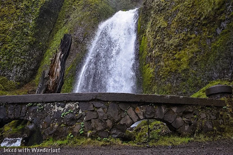
Located in the awe-inspiring Columbia River Gorge right off of the Historic Highway is the beautiful, easily accessed 120-foot waterfall, ‘Bridal Veil Falls’.
It’s part of the Oregon State Scenic Viewpoint and is on the site of an old lumber mill. The park is open year round and there are no entry or parking fees.
*If you’re visiting between May and September, you’ll need a vehicle permit to enter the Waterfall Corridor.
We were fortunate enough to discover this waterfall during our visit in March 2022. We learned quickly that Multnomah Falls wasn’t the only amazing waterfall around here.
In fact, there are MANY gorgeous waterfalls on the Oregon AND Washington side of the river. This post, though, will focus on Bridal Veil.
So are the trails difficult or easy? What can you expect once you reach the falls? How do you get there? We’ll answer these questions and more below!
Here’s some gear we recommend…
Getting To Bridal Veil Falls and Permits
Getting There
Bridal Veil Falls can be found along Oregon’s Waterfall Corridor inside the Columbia River Gorge. It’s super easy to find as its parking lot is right off the highway.
The exact address is E Crown Point HWY, Bridal Veil, OR 97010. Simply plugging, ‘Bridal Veil Falls’, into your GPS will suffice.
From Vista House: Leaving the Vista House lot, drive east on Historic Columbia River Highway for 4.5 miles. It’ll be the next waterfall AFTER Latourell Falls and the parking lot will be on your left (across from the Lodge).
From Cascade Locks: Travel west on Interstate 84. Take exit 35 to the Historic Columbia River Highway. It’ll be the next waterfall after Wahkeena Falls and the parking lot will be on your right. Total milage is around 18 miles.
From Portland: Make your way to Interstate 84 east and stay on it for about 25 miles. You’ll take exit #28 (look for signs stating Bridal Veil and/or Angel’s Rest) and follow the signs for the Historic Highway. The parking lot will be on your right.

You’ll know you’ve arrived to the correct lot (aside from the signage) when you see Bridal Veil Falls Lodge across the street.
The park is located in between two equally beautiful waterfalls, Latourell Falls and Wahkeena Falls. Unlike them, though, Bridal Veil is on the north side of the highway.
Fees
There are no fees for Bridal Veil Falls, but if your visit coincides with the May through September timeframe, you will need a permit to access the Historic Highway.
The fee for this permit is $2 per vehicle and they will be verified by State Parks Staff between Bridal Veil (near exit 28) and Ainsworth State Park.
Trails to Bridal Veil Falls
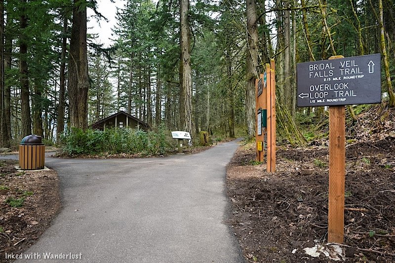
Overlook Loop Trail
On arrival, you’ll have a choice to make. You can go straight on the traditional Bridal Veil Falls trail or you can bear left to the overlook.
Initially, we had every intention of doing both (they are not connected). We were going to do the main trail, come back, and then go to the overlook.
However, we spent more time than we thought we would down there and by the time we got back to the split, we had run out of time.
We had dinner reservations in downtown Portland and if we didn’t leave at that moment, we would’ve missed it. So we had to bank it for next time.
Based on pictures we’ve seen, the trail is half a mile (roundtrip) and terminates at a wooded platform overlooking the top of the falls (similar to the one we went to).
*At the split (just off from the parking lot) you’ll find a restroom open to public use
Bridal Veil Falls Trail
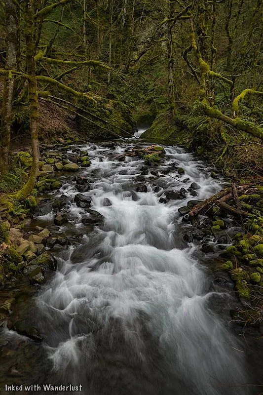
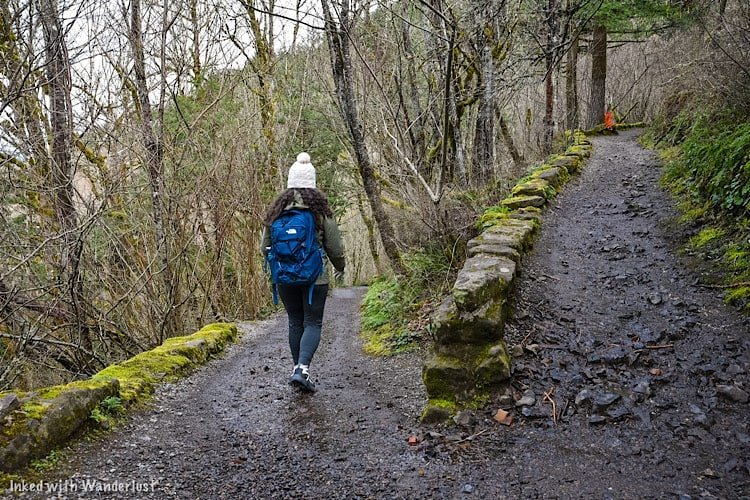
The main trail to the base of falls is 3/4’s of a mile (roundtrip) on a slightly steep decent to Bridal Veil Creek and the falls.
It had just rained during our visit so the trail was a little muddy, but we had no problem navigating it. We would rate it as easy going down and easy to moderate going up.

Soon after the second switchback is when you’ll run into the first of two bridges on the trail. This bridge is followed by a concrete stairwell leading you to the next bridge.
The second bridge takes you across Bridal Veil Creek and leads you to yet another stairwell, this one taking you up to a wooded viewing deck for the waterfall.

Take the stairwell to the viewing deck overlooking Bridal Veil Falls. The deck isn’t big so if it’s busy, you’ll have to hang out for a few minutes until a spot opens.
There are many different perspectives of the waterfall from here. If you’re into photography, you can get pretty creative here.


When you’re done, simply head back in the direction you came to the trailhead. From there, you can leave or see the top of the falls from the Overlook Loop.
Additional Things To Know
It is visible from the road, but don’t do it. That road is very narrow and the chance of a vehicle vs. pedestrian accident occurring is high. View the falls from one (or both) of the trails, not the road.
Drone use is prohibited. Like most of the gorge, drone use is not allowed at Bridal Veil.
No EV charging stations. The nearest ones are to the west of Bridal Veil in Troutdale.
Restroom is available. There is a restroom (vault variety) just ahead of the trail split near the parking lot.

Nearby Attractions
This area is littered with amazing natural sights, most of which require little to no effort to see (aside from driving around).
There’s so many that we couldn’t possibly list them all, but we will list a few of our favorites. If you’d like to see more, check out the website, Ready Set Gorge.
Multnomah Falls - The tallest waterfall in Oregon and one of the most visited natural sites in the PNW. Check out our guide by tapping/clicking on the link.
Vista House (Crown Point)
Wahkeena Falls
Oneonta Gorge (currently closed)
Bridge of the Gods (connects Oregon and Washington)
Latourell Falls
Ainsworth State Park
Horsetail Falls
Fairy Falls
Angel’s Rest (hiking trail)
And so much more!
A Quick Note…
We’re often asked about the equipment we use to capture the photos on our website. Below, we’ve added Amazon links to those products and others that we recommend.
If you decide to purchase, Amazon will pay us a small commission. This helps us keep Inked with Wanderlust running and doesn’t cost you anything extra.
“Understanding Exposure” by Bryan Peterson (this book is a great resource for anyone starting out in photography)
It is our hope that this article was helpful to you in planning your next adventure. If so, please share it with your family and friends on Facebook or Pinterest.
You can further show support by subscribing to our newsletter below. In it, you’ll receive a once weekly newsletter containing announcements, new post alerts, news, and more!
If you have any questions, comments, or suggestions, please engage with us in the comment section below.
Thanks for reading and safe travels!

Best Time to Visit Shoshone Falls in Southern Idaho
Coming in at a height of 212 feet and a width of 900, Shoshone Falls is one of Southern Idaho’s most popular natural attractions. Surpassing the height….
At a height of 212 feet and width of 900 feet, Shoshone Falls is one of Southern Idaho’s most popular natural attractions. Surpassing the height of its New York counterpart, Niagara Falls, it’s fittingly referred to as the Niagara of the West.
Shoshone Falls is located just 7 miles from Twin Falls proper, making it easily accessible to anyone with a car. Its natural beauty, impressive flow, and ease of access makes it abundantly popular, attracting more than five hundred-thousand spectators annually.
Despite its popularity, Shoshone Falls doesn't always flow at its fullest. This is due to both natural reasons, such as snowmelt, and agricultural reasons, as a portion of the river that feeds the falls is diverted for irrigation purposes, which reduces the flow over the falls.
There's nothing worse than arriving to the falls, expecting to see it in all its grandeur, and see nothing but a drip. That happened to me on my first visit, so I want to help reduce your chances of that happening. This post will cover (what I feel) is the best time to visit Shoshone Falls. I'll also discuss getting there, fees, what to expect, and more.
Getting to Shoshone Falls

As stated above, Shoshone Falls is located just seven miles outside the city of Twin Falls in Southern Idaho and getting to the falls is fairly straightforward. Starting from Twin Falls:
You’ll head northeast on Shonshone Street towards 2nd Ave
Take a slight right on Addison Ave
Turn left on Champlin road. Stay on for 2.5 miles and stay left at the junction before arriving at the parking lot
For GPS purposes, the exact address is 4155 Shoshone Falls Grade Road, Twin Falls, ID 83301
On the way, you’ll drive through beautiful farmlands before descending into an impressive canyon as you make your way to the falls. If you pay attention and you’re here at the right time of year, you’ll see little streams of water descending the canyon walls around you, making it an impressive sight. This usually occurs in early spring or late spring.
Parking and Entrance Fees

Between the months of March and September, there is a fee to visit the falls (and Dierkes Lake, which is also within the confines of Shoshone Falls Park). The fee is just $5 per vehicle. You'll pay at the toll booth near the entrance. You can pay with cash or credit/debit card. If you plan to visit five or more times during the season, consider purchasing an annual pass at just $25.
It’s worth mentioning that when we came here in late June (close to sunset), there wasn't anyone present collecting fees, nor was there a self-pay station. We just drove right in and parked, prepared for someone to approach us for the fee, but no one ever did. Not sure if this is a common occurrence, though.
The parking lot is fairly large and paved, capable of holding many vehicles, RVs, and tour buses. If you're here is the summer months, there's a good chance the lot could fill. Be prepared for that possibility. For weekends in the summer, I would plan to arrive early.
Shoshone Falls Observation Deck
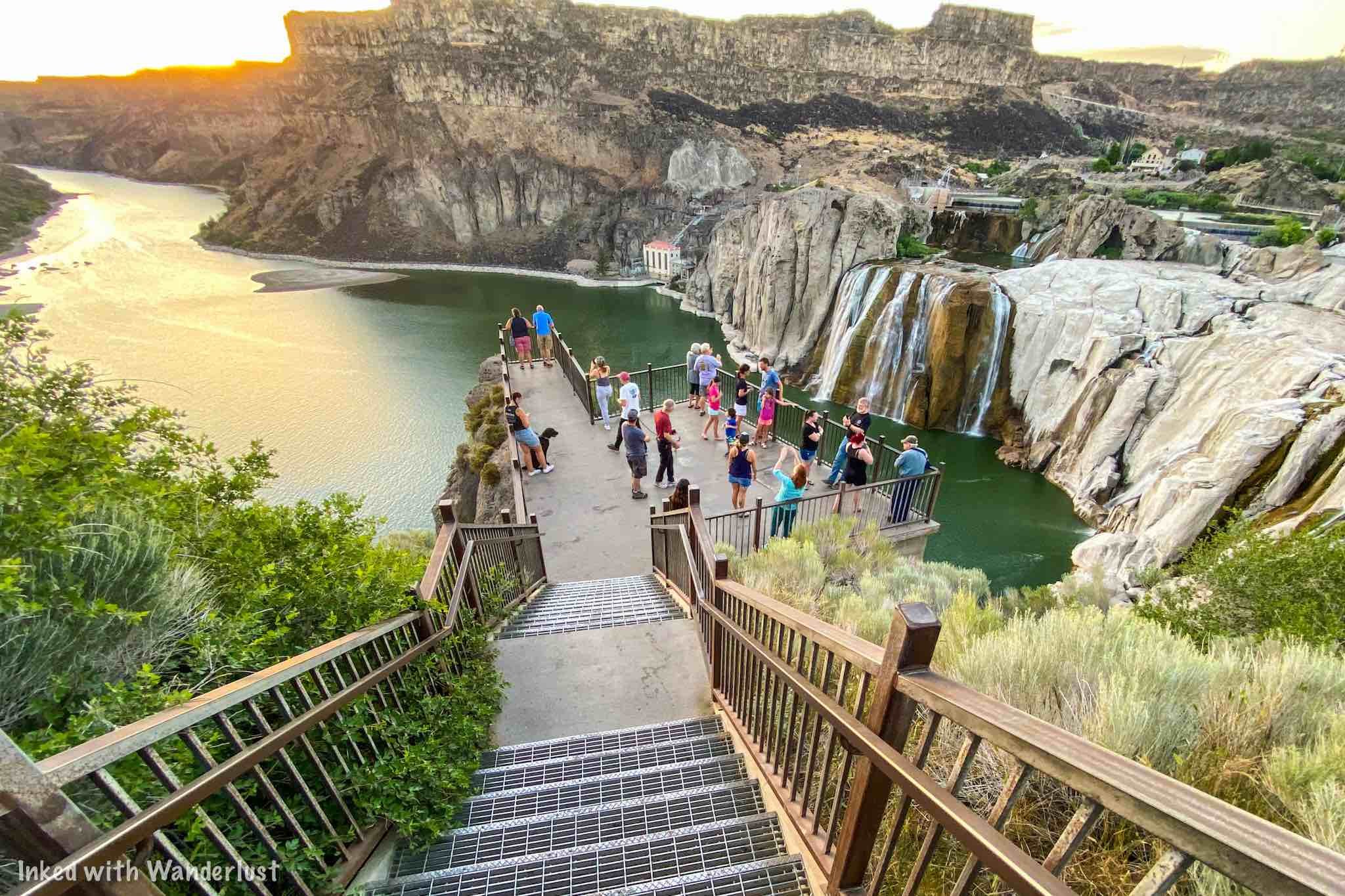
From the parking lot, there are a few viewing platforms to see the falls from. The middle one (the closest, most popular and largest) is right off the lot and is accessed by a stairwell. Uphill and to the right is where you’ll find another viewing platform. This one was our least favorite as there was lots of shrubbery blocking the view.
In the opposite direction, to the left, is a higher platform and was our favorite as it gave us a great view of not just the falls, but the Snake River as well. This viewing area was also muchless crowded than the main one.
If you're here at the right time of year when the spring runoff is at its peak, the roaring sound of the falls you'll hear from the observation deck is an unreal experience.
Best Time to Visit Shoshone Falls

This was something I wish I researched more before going. Starting in the summer, much of the river is diverted for irrigation purposes, and this causes the flow over the falls to dissipate to near dry levels (we were here in late June and flow was minimal). If there's a healthy amount of snowmelt, you'll still see a decent flow, though.
If you come in the fall, the falls will look nearly dry as the snow has mostly melted away by this point, as the remaining flow is used to recharge the reservoir system upstream. This process usually begins in late summer. If you must stick with the summer months, then early summer is your best bet.
Winter is a craft-shoot, as the flow can be decent. However, there's always the possibility of a portion of the falls freezing over, reducing the flow. In addition, you'll be dealing with potentially slick conditions on not just the road, but the viewing decks as well.
All that said, in my opinion, the best time to visit Shoshone Falls is between the months of April and early June. April is right about when the snowmelt begins to show itself and if it was a healthy winter, the impressive water flow will continue throughout spring.
Around late May to early June is when you'll begin to see a reduction in the flow of the river, as that's when the irrigation process begins. If you're here during these times (or later in the summer), your best bet would be to arrive early, as Idaho Power typically diverts later in the day, leaving the morning with decent flow.
Nearby Attractions in Twin Falls

Shoshone Falls may be the most known attraction in the area, as it’s Idaho’s largest waterfall, but you could easily spend a few days or more exploring everything Twin Falls (and the surrounding area) has to offer. Below are just a few of my top suggestions.
Evel Knivel Jump Site

Located downstream from Shoshone Falls is where you’ll find the location where famed daredevil, Evel Knievel, attempted to launch himself over the Snake River in a steam powered “skycycle”. You’ll scratch your head in disbelief when you see for yourself the sheer magnitude of this attempted jump and make you wonder what the @#$! he was thinking.
Perrine Bridge

Further downstream from the falls and jump site is the Perrine Memorial Bridge. This impressive bridge spans 1500 feet across Snake River Canyon and connects the cities of Twin Falls and Jerome. Both sides of the bridge have parking lots and viewing decks and much like most popular bridges, there’s a pedestrian walkway you can utilize.
Twin Falls Visitor Center

Near the Twin Falls side of the bridge is where you’ll find the city’s visitor center. It’s a beautiful building that features merchandise, knowledgeable employees, photography displays of local attractions, and its own viewing deck of the canyon, bridge, and river.
Shoshone Ice Caves

Located outside the town of Shoshone, Idaho (about 45 minutes from Twin Falls), the Shoshone Ice Caves tour is a MUST if you’re in the area. Your tour guide will take you through a 1,000 foot lava tube on walking planks above the ice. On a hot day, this is the perfect activity to take part in.