
The Ultimate Snoqualmie Falls Guide
Nestled just 30-minute or so drive from the hustle and bustle of downtown Seattle in the beautiful Snoqualmie…
Disclosure: This post contains affiliate links. If you make a purchase through these links, I may earn a small commission at no additional cost to you. I only recommend products or services that I believe will add value to my readers.
Nestled just a thirty minute drive from the hustle and bustle of Seattle in the beautiful Snoqualmie Mountains is one of Washington State’s most popular attractions, the 270-foot tall, Snoqualmie Falls.
While the falls have always been an amazing sight to see, an explosion of popularity occurred in the early 1990’s when the waterfall was prominently featured in the hit TV series “Twin Peaks”. It now brings in 1.5-million visitors, annually.
No visit to the area would be complete without at least making a quick stop to view it from the upper deck. Whether you spend ten minutes or two hours, coming out is worth the effort.
So whether you're looking for great day trips from Seattle or you want to spend a day away from the city, this guide has you covered. Let’s get into it.
Getting to Snoqualmie Falls

If you’re like most people, you’ll be coming to the falls from Seattle. It’s a fairly straight forward drive from the city to the upper plaza, making it the perfect day trip.
The exact milage will vary depending on where you’re starting from generally, it's a bit more than thirty minutes, one-way, with only a few turns.
From Seattle, the directions are as follows:
Look for signs pointing you to I-5 South and get on it.
Follow the signs to the I-90 East turn off and stay on it.
Take exit #25 toward Snoqualmie Pkwy and turn left on WA-18E
Turn left on Railroad Ave then stay on Railroad Ave after the traffic circle (3rd exit)
Shortly after, you’ll see the entrance for the falls on your left.
Parking at Snoqualmie Falls

You’ll have two options for parking and they’re both incredibly easy:
Option #1 would be the main lot right off the rim. It’s large enough to accommodate many vehicles but since it’s closest to the falls, there’s a fee. It’s $7 for a two hour period and $5 for each additional hour. The fee can be paid at the self-serve kiosks near the Visitor Center (you will need to know your license plate number).
Option #2 is the larger parking lot across the road that connects to the park via an overhead bridge. This lot can accommodate many more vehicles and is free. It’s also ADA accessible. So if the main lot is full, fret not. Just head across the street.
The recently renovated Visitor Center and Gift Shop are fully open to the public. It includes new exhibits, restrooms and an ice cream shop. Their hours are as follows:
Monday - Friday: 10am - 4pm
Saturday & Sunday: 9am - 4pm
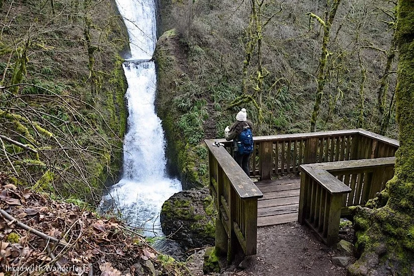
Snoqualmie Falls Upper Viewing Deck

If you type “Snoqualmie Falls” into your phone’s GPS, it’ll likely take you the parking lot at the Upper Plaza. It’s the most visited area of the park as it provides that classic view of the falls from the rim.
Here is where you’ll see an exhibit of an old, used turbine. These are used in conjunction with the force of the falls to generate energy for the surrounding area.
We’ll go over this further into the post as it’s the Lower Plaza where you’ll see a grandeur example of this at work.

To the right of the turbine is where you’ll find the beginning of the trail that leads to another viewpoint and to the Lower Plaza below.
This trail is less than half a mile but you will drop you nearly 300 feet. While it’s fairly easy going down, coming back up will be challenging, unless you’re in decent shape.
Before descending the trail, there’s another viewpoint worth checking out. This is called the, “Peregrine Viewpoint”. Named after the birds who inhabit this area. It’s a little further down and it’s a slightly more straight-on view of the falls.
Lower Park Plaza

The Lower Plaza is not as well known. It is here where you’ll get the “down below” view, access to the Snoqualmie River and see the energy producing turbines up close and personal.
You have two options to get the lower plaza from above:
As stated above, you can hike the roughly half mile trail. It’ll take you straight to it but you will have a jaunt going back up. It’s not advisable if you’re not in decent shape and/or don’t have the proper footwear.
Your other (much easier) option would be to drive to it. Turn left out of the main lot or right out of the free lot and head down the road for a few miles. You’ll turn left on Fish Hatchery road and follow that until it terminates at the lower plaza parking lot.

You’ll find the trail leading to the lower viewing deck to the right of the visitor center. Before reaching the boardwalk, you’ll see further examples of turbines and other process equipment with literature explaining how they were used.
Past here, you'll head down a series of stairs and onto a scenic boardwalk with the roaring Snoqualmie River on one side and beautiful moss covered trees on the other. This short journey to the deck is worth the visit all its own.
I didn’t check the exact amount of time it took to reach the deck from the parking lot but including stops to check out the turbines and take photos, it probably took me less than 10 minutes.


The deck is fairly small and can comfortably fit a dozen or so people at a time. Keep this in mind if you’re visiting on a particularly busy day.
The view of the falls from the deck is unique compared to the top. In my opinion, it’s superior to the rim view, as you get the river and surrounding greenery creating a magical scene.
Once you’ve gotten your fill of the views and took your pictures, simply turn around and head back the same way you came in.
Best Time to Go

That’s relative to your personal tastes. Most will tell you spring is the best time due to the fresh run-off from the mountains. If your goal is to see Snoqualmie at its fullest, spring would be the time.
I was here in early March (not quite spring). The runoff was decent and there were no crowds to deal with. Weather wise, the warmth of summer would be the way to go, but it’ll be the most crowded.
Late September and October will bring beautiful fall foliage to complement the scenery around the falls. Winter, while easily the least crowded of any season, brings cold weather with possible snow and ice.
My personal recommendation would the months of eMarch or April. Chances of snow and ice are minimal, as are the crowds. The runoff, in my experience, is good but your results may vary. It was a bit chilly during my visit, but the lack of crowds made it worthwhile.
Nearby Attractions

While making the trip from Seattle to Snoqualmie to see the falls is more than worth the effort, it isn’t exactly an all-day outing.
We were able to see the falls and what it had to offer in a couple hours. Since you’re heading out there anyway, may as well see what else Snoqualmie has to offer.
Hiking Trails

There are many hiking trails in the area. The most popular being Rattlesnake Ledge. The trailhead is located about 10 minutes from the falls in Snoqualmie Point Park and while it requires some effort to complete, it’s short and sweet with an epic payoff. Check out AllTrails for more information on that.
Historic Train Museum

Located on the side of the road heading into downtown Snoqualmie is a line of preserved, historic trains, free for public viewing.
There’s an easy, paved trail that runs alongside all of them and makes for an excellent outing for families with small children.
Local Shops & Restaurants

Along the main road that cuts through town you can find many local shops and eateries to dine at. Supporting local businesses, especially now, is a great way to complete the experience. My personal favorite, Caadxi Oaxaca, serves up amazing spicy pork and fish tacos
Lodging
If you’re keen on staying in the area, you have a few options. You have your standard chain options such as Holiday Inn and SpringHill.
If you’re a Marriott Bonvoy member, you have a couple options in nearby Redmond and Bellevue. The best option, however, would be the Salish Lodge and Spa. It overlooks the falls at the rim and is an utterly beautiful property.


The Ultimate Multnomah Falls Guide
At 611-feet (between the upper and lower portions), Multnomah Falls is the tallest waterfall in Oregon and the crown jewel…
Disclosure: This post contains affiliate links. If you make a purchase through these links, I may earn a small commission at no additional cost to you. I only recommend products or services that I believe will add value to my readers.
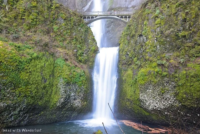
At 611-feet (between the upper and lower portions), Multnomah Falls is the tallest waterfall in Oregon and the crown jewel of the state.
It’s been on our bucket list for quite some time and recently, we were fortunate enough to finally see it for ourselves. Let me tell ya, it was every bit as epic as we were expecting.
We discovered, however, that depending what time of year you go, it isn’t as simple as just, ‘showing up’. You will have a few things to iron out before going.
So what do you need to know before going? Will you need a permit? Is there an admission fee? How do you get there? We cover all of that and more below. (Updated for 2025.)
*A big fire ripped through this area a few years ago and severely damaged many trails. Some have been repaired and reopened, but others remain closed. For up-to-date information on trail closures and what’s open, refer to the website, “Ready Set Gorge”.
*Multnomah Falls, including its trails, are open to the public.
Directions To Multnomah Falls
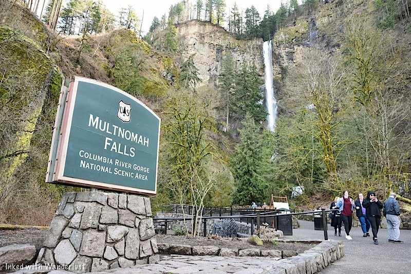
Multnomah Falls is easy to get to and is conveniently located right off of the Columbia Gorge Historic Scenic Byway.
The nearest town to it is Troutdale, Oregon, but it isn’t far from major cities like Portland and Vancouver. In fact, it’s only a 30-minute(ish) drive from either.
Distance to Multnomah Falls
From downtown Portland: 32 miles or a 35 minute drive
From Portland Airport: 26 miles or a 30 minute drive
From downtown Vancouver: 34 miles or a 40 minute drive
From Salem, Oregon: 75 miles or a 1 hour and 20 minute drive
From Eugene, Oregon: 140 miles or a 2 hour and 15 minute drive
It’s one of the most visited natural sites in the Pacific Northwest, so road signage is plentiful. Plugging in, ‘Multnomah Falls”, into your GPS of choice will get you there easily.
What we suggest you do, especially if you’re coming from Portland, is to start at Vista House and then work your way from waterfall to waterfall along the Historic Columbia River Highway.
Multnomah Falls Parking

There are two parking lots at Multnomah Falls. The closest is the small one directly across the street from the lodge along the historic highway. By our estimate, it can hold around fifty vehicles.
If you’re able to snag a spot here (like we did), it’ll grant you the fastest and most convenient access to the falls. Just cross the street and you’re there. In addition, you won’t need a parking permit.
It’s a small lot, though. We were here in March, arrived early, and got the second to last available spot. In the summer months, it can and does fill quickly.
The larger lot is right off of I-84 via exit 31. A walking path leads you from the lot, under the highway and to the crosswalk. There’s no fee during the off-season. However, between May and September, you’ll need a timed use permit (more on that below).
Multnomah Falls Timed-Use Permits
During the summer months, you will need a timed reservation in order to park at the I-84 lot (exit 31). In 2024, the official timeframe is May 26th - September 4th.
*Note: There hasn’t been an announcement as of yet pertaining to timed reservations for 2025. However, considering the program’s success over the prior two seasons, I expect more of the same for 2025.
Timed reservations are made through Recreation.gov and there are two options to consider:
Option One: Timed reservations become available 14-days from your desired date, starting at 7am PST, on a rolling daily period. For example, if your desired date is August 15th, reservations become available August 1st. at 7am PST.
Option Two: A certain (unspecified) amount of timed reservation permits will be available for same-day, in person pick up at the Gateway to the Gorge Visitor Center in Troutdale and at the Cascade Locks Historical Museum.
The fee for a reservation is $2.00, per permit. You’ll only need one permit, per vehicle. This is NOT a per person charge. If you arrive early enough and find parking at the small lot along the historic highway, a timed use permit is NOT required.
In 2022, Oregon officials decided to restrict access to the historic highway (waterfall corridor) between Bridal Veil Falls and just past Multnomah Falls via a timed use permit during the summer months.
For 2023 (and presumably beyond), they’ve decided to contain the permit requirement to just the I-84 parking lot for Multnomah Falls. You will NOT need an additional permit to access the waterfall corridor.
Some other things you’ll need to know:
You must arrive at the time stated on your reservation. You’ll be given a one-hour grace period. After that, your reservation becomes invalid.
You can show either a printed copy or the digital version (preferred).
Drop-offs in front of the Lodge will not be allowed.
Once you’re there, you can stay for as long as you like.
Timed reservations are NOT required if you arrive via shuttle, bicycle, or tour.
Shuttle Service To Multnomah Falls
Taking a shuttle to Multnomah Falls is an excellent alternative to driving and dealing with the traffic congestion.
There are numerous operators, each with their own fees, operation schedules, and pick-up locations. All, however, offer hop-on/hop-off privileges at all the main sites.
These include:
Multnomah Falls
Crown Point (Vista House)
Latourell Falls
Bridal Veil Falls
Wahkeena Falls
Horsetail Falls
And more!
Fares vary, but between the three that we’ve found, it seems to be a range of $15 - $21, per adult. Some include one child in the price.
Here are the shuttle operators. Tap or click the name to go to their website:
The cost of shuttles are way more than the reservation fee for sure, but the advantages of not having to worry about getting one at all or dealing with parking may be worth it to you.
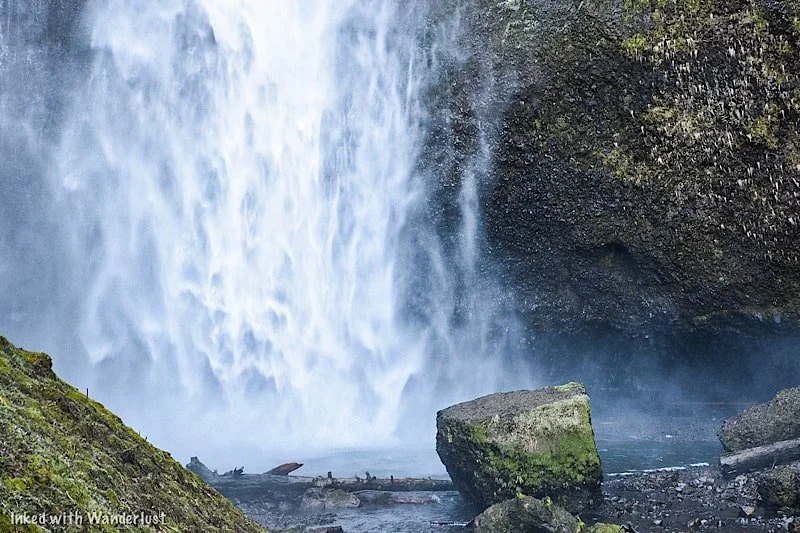
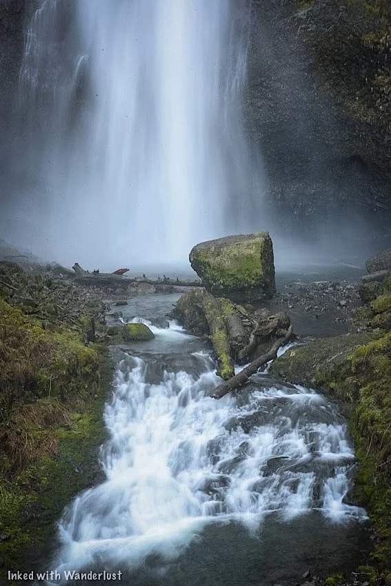
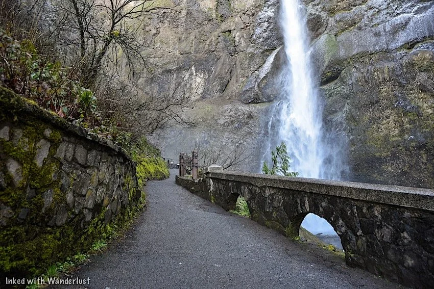
Lower Viewing Deck

The main viewing deck is in front of the lower section of the falls. It’s the easy to get to as it’s just to the left of Multnomah Falls Lodge.
There’s a ramp to the right of the stairwell enabling access for wheelchairs and strollers. You can enter the ramp near the lodge’s snack bar.
It’s where most people view and photograph the falls from and is open year round. Even on a busy day, there’s plenty of elbow room.
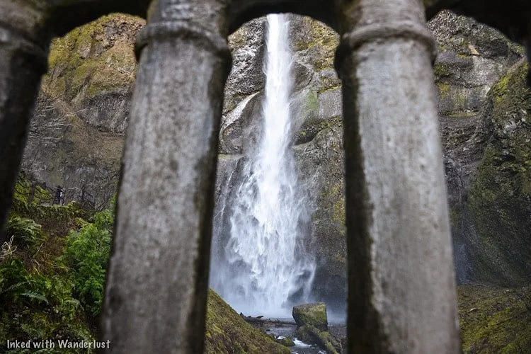
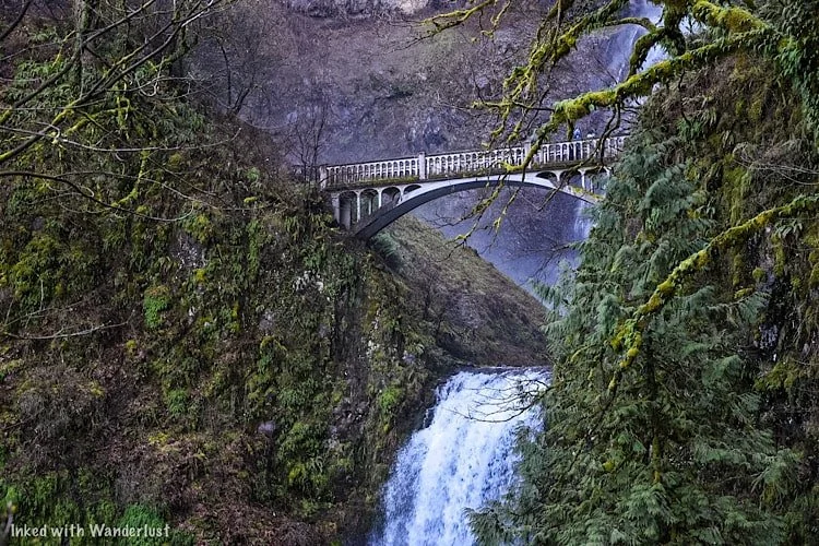
Benson Bridge
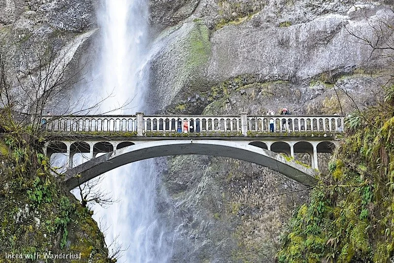
The footbridge is a unique feature of Multnomah Falls. It is named after a man named Simon Benson, who is the person responsible for the bridge’s conception.
It was built in 1914 and is made of reinforced concrete. It spans across Multnomah Creek, between the waterfall’s two cascades, 105-feet above the base of the lower fall.
It provides unparalleled views of the upper section and connects visitors to the trail leading to the top of Multnomah.
To access the bridge, you’ll see an iron gate to the side at the lower viewing deck. Go through the gate and continue up the Larch Mountain trail.
*During winter, the bridge is known to freeze over. If this occurs, that gate will be closed and visitors are not allowed past that point.
From the lower viewing deck, it’s a 2/10’s of a mile, steadily uphill walk to the bridge. It is paved and the falls are within view nearly the entire route.
Hiking Trails To The Top & Beyond
If you’re feeling up to it, you can continue for another 8/10’s of a mile (one-mile from the bottom) to the top of Multnomah Falls.
You’ll be going up switchbacks the entire way and there’s a small viewing deck at the end overlooking the top of the falls.
We decided against this as the bridge was fairly iced over and we were told by others coming back down that the trail itself was worse.
If it’s warmer while you’re here, we definitely recommend going up there. We’ll be doing it on our next visit for sure.
There are two other destinations you can reach from this trail. They are:
Wahkeena Falls: Via the Wahkeena Trail portion, you’ll continue past the upper deck of Multnomah Falls and will eventually reach Wahkeena Falls, passing multiple other waterfalls along the way. Total milage from the bottom is 1.8-miles.
Larch Mountain: For those looking for a challenge, hike up to Larch Mountain. Based on the pictures we’ve seen, the views are spectacular. Total milage from the bottom is 6.8-miles.
SEE MY TOP RECOMMENDATION FOR A DAY HIKE BACKPACK ON AMAZON HERE!
Multnomah Falls Lodge

Multnomah Falls Lodge is an authorized concessioner providing many amenities to visitors. It features a gift shop, restroom, restaurant, and espresso bar.
If you want to dine here, specifically in the summer months, reservations are highly ecouraged. If you want to check out their menu, go here.
If you’re like us and visit during the off-season, you shouldn’t have a problem getting a table. We walked in and we’re seated right away.
The service was great, we were seated at a table with a great view of Multnomah, the beer was cold, and the food was good.
Nearby Lodging
Despite the name suggesting so, Multnomah Falls Lodge doesn’t have a hotel attached to it.
If you’ll be spending the majority of your vacation in the Columbia River Gorge, here are a few hotels located nearby:
Columbia Gorge Hotel: In Hood River, Oregon, 25-miles east
Best Western Columbia Inn: In Cascade Locks, Oregon, 11-miles east
Edgefield Manor: In Troutdale, Oregon, 18-miles west
So where should you stay? That’s dependent on your preferences, plans, and budget. If you’re coming strictly for the gorge, we would recommend staying in Troutdale or Cascade Locks.
If you plan to visit Portland as well, basing yourself in the downtown area and driving/shuttling into the gorge may make more economic sense.
Weather and Best Time To Go
We visited Multnomah Falls in March of 2022. The weather, while a bit chilly in the morning, was great and we experienced very little in the way of crowds.
If your goal is to see Multnomah at its peak flow and the least amount of visitors possible, we recommend visiting in either winter or mid-spring.
Just keep in mind that due to the mist from the upper fall, Benson Bridge often freezes over and thus, the bridge and trail closes to the public for safety.
In winter, the lower viewing deck could also be frozen over due to snowy conditions.
During our visit, the bridge was partially frozen, but open. We witnessed more than a few people nearly eat concrete (including us) because of it.
If you want to ensure that you can access the bridge, then summer or fall would be the times to go. However, these months come with their own downsides:
Crowds get thick.
Parking can be difficult to come by.
You’ll need a timed reservation to go.
The flow dies off a little bit (winter/spring is the peak).
It’s hot (summer)
If you can stomach the above challenges, then visiting during summer or fall would be the way to go if Benson Bridge is important to you.
For our next visit, we plan to go during the fall. We’ve seen photographs of the fall foliage in the gorge and it is simply stunning.
Additional Information & Reminders
There are no EV charging stations. The nearest ones are in Troutdale, Oregon, west of Multnomah Falls.
Drone use is prohibited. It’s painful, but true. As of January, 2022, the use of drones at Multnomah Falls is prohibited.
Reservations may be required. If your visit coincides with the mid-May to mid-September timeframe, you will need a reservation through recreation.gov.
There are amenities. There’s a clean restroom, gift shop, ATM, snack bar, and restaurant on-site, but no lodging. The closest hotels are in either Troutdale or Cascade Locks.
The bottom platform is handicap accessible. There’s a ramp adjacent to the stairs leading to the bottom platform. All of it is paved. The trail going to bridge, while paved, is not accessible.
Pets are allowed. As long as they’re leashed, you can bring your pet.
Benson Bridge may be closed during your visit. If it freezes over, Benson Bridge closes to the public.

A Quick Note…
We’re often asked about the equipment we use to capture the photos on our website. Below, we’ve added Amazon links to those products and others we recommend.
If you decide to purchase, Amazon will pay us a small commission at no additional cost to you.
“Understanding Exposure” by Bryan Peterson (this book is a great resource for anyone starting out in photography)
“The Landscape Photography Book” by Scott Kelby (another great resource for beginners)

Latourell Falls: A Stunning Waterfall Near Portland Oregon
Of all the waterfalls in the Columbia River Gorge, Latourall Falls, a 224-foot single-plunge fall, is the closest to Portland…
2 minute read | contains affiliate links
Of all the waterfalls in the Columbia River Gorge, Latourall Falls, a 224-foot single-plunge fall, is the closest to Portland.
It’s also your first introduction to what is known as the, “Waterfall Corridor”, a miles-long road featuring an endless amount of waterfalls.
So how do you get to Latourell Falls? How long is the trail? We answer all these questions and more below.

Quick Stats
Location: Guy W. Tolbot State Park (Corbett, OR)
Fee: None
Permit: If you’re here during the summer season, you’ll need a permit to access the waterfall corridor
Open: Year round
For: Hikers
Restroom: In the parking lot
Parking: Large lot at the trailhead
EV Stations: None
Difficulty: Easy
Popularity: High
Trail Type: Loop
Mileage: 0.2 - 2.4 miles (depending how far you take it)
Elevation Gain: Up to 639-feet
Condition: Maintained
Features: Two waterfalls if you complete the loop
Pets: Allowed on leash
Drones: Not permitted
Hazards: During winter or late spring, the trail can be dangerously icy
Our Visit(s): March 2022
Getting There & Parking

If you’re like most people, you’re probably coming from Portland. If so, then plug, “Vista House”, into your phone’s GPS.
Be sure to pull over and spend some time taking in the views of the Columbia River Gorge from here. They’re stunning.
When you’re done, get back on the road and continue going around the Vista House. From there, it’s only 2.5-miles to Latourell Falls.
Shortly after crossing a moss-covered bridge, you’ll see the parking lot on your right. It’s a fairly large lot with restrooms.
Decide Between The Loop or The Base
Latourell Falls can be partially viewed from the handicap accessible viewing deck adjacent to the parking lot.
For the full experience, though, take either the paved, short trail to the base or complete the full loop.
The trail to the base of the falls is just 0.2-miles (or about a 5-minute walk)
The loop trail is 2.4-miles and takes you up and over to another waterfall (Upper Latourell) and then down to the base of Lower Latourell.
If at first you decide to go to the base but later change your mind and want to do the loop, cross the footbridge at the base and continue on.
If you want to begin with the loop, you’ll see the trailhead to the left of the base trail. It’s an immediate climb from the get-go.

We were here in March and it was especially rainy and cold that morning. Due to this, much of the loop was iced over. So we just did the base.
As stated above, the trail to the base of the falls is mostly paved and only takes about 5-minutes.
This portion of the trail ends at a small look-out directly next to the waterfall. It enables you to get very close.


Due to this, expect it to be misty and on top of that, icy if you’re here in winter or early spring.
The area around the falls is like a fairytale with all the moss covered trees. Even the fall’s basalt-rock wall has moss all over it.
To your right, you’ll notice a footbridge crossing over the creek. This is where you’ll continue along the loop if you wanted.


This footbridge can be especially icy in the right conditions. It was when I was there. I almost biffed it a few times trying to take these photos.
If you don’t want to continue onto the loop, simply head back the same way you came to return to your vehicle.

Additional Waterfalls Nearby
Latourell Falls is only the beginning. There are many, many more waterfalls as your progress further down the corridor.
A few of those are:
Bridal Veil Falls: Read about our visit here
Wahkeena Falls: Read about our visit here
Multnomah Falls: The tallest waterfall in Oregon! Read about our experience here
Your Thoughts…
Does Latourell Falls seem like a place you and your family would enjoy?
Let us know in the comments below! We love hearing from our readers.
Please support our website by subscribing to our newsletter below.
Thank you for reading.
Check Out These Amazing California Destinations!


A Quick Guide To Visiting The Beautiful Wahkeena Falls (Oregon)
Wahkeena Falls (Wa-Kee-Na) is a multi-tired waterfall along Oregon’s famed, ‘Waterfall Corridor’, in the awe-inspiring Columbia River…
5 minute read | Contains affiliate links
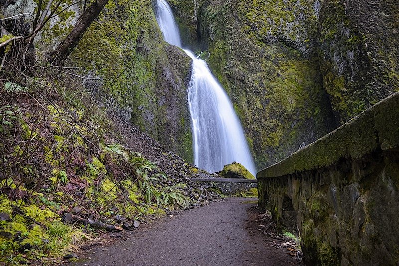
Wahkeena Falls (Wa-Kee-Na) is a multi-tired waterfall along Oregon’s famed, ‘Waterfall Corridor’, in the awe-inspiring Columbia River Gorge.
Named after the Yakama word for, “most beautiful”, Wahkeena Falls has a total height of 242-feet. It may not be as tall as its neighbor, Multnomah Falls, but it’s no less gorgeous.
In this quick guide, we’ll show you a few of the photos we took during our visit and fill you in on some details you’ll want to know before visiting. Let’s do this!
Here’s some great hiking equipment we recommend…
Wahkeena Falls Information

Getting To Wahkeena Falls
Distance from:
Portland: 29 miles east (30 minute drive)
Troutdale: 14 miles east (17 minute drive)
Vista House: 8 miles east (19 minute drive)
Multnomah Falls: 8.5 miles west (15 minute drive)
Cascade Locks: 14 miles west (22 minute drive)
Vancouver: 32 miles west (33 minute drive)
Bend: 162 miles north (3 hour and 15 minute drive)
Coming from Portland or Troutdale, you’ll be on I-84 east for most of the drive. You’ll take exit #28 to Bridal Veil and continue straight on the Historic Columbia River Highway.
From Cascade Locks or further, you’ll travel on I-84 west before taking exit #35 and merge onto the Historic Highway.
If you’re coming from the west, Wahkeena Falls will be after Bridal Veil Falls on your right. If you’re coming from the east, it’ll be after Multnomah Falls on your left.

Parking
Even during the off-season, parking can be scarce at Wahkeena Falls. There’s a small pull-out style lot across the street and an even smaller one in front of the entrance.
When we arrived, both were full. We were here in March, which isn’t a particularly busy time. So in the summer, we can imagine how insane it gets.
If you find yourself in the same situation, do what we did and circle around. This is a spot where most people get out of their car, check it out, and move on.
Chances are good that if you circle around - or even just come back to it later - you’ll snag yourself a spot. Patience will take you far, here.

Hiking At Wahkeena Falls
You can partially view the waterfall from the main viewing deck below, like most people. If you want a great view, though, take the trail up to the footbridge.
While not as famous as Benson Bridge over at Multnomah, Wahkeena Falls has a bridge of its own and yes, you can walk up to it!
Standing in the parking lot and facing Wahkeena Falls, the trail is to your right. If you take the one to your left, you’ll end up at Multnomah.
The trail is part dirt, part gravel and is a 2/10’s of a mile, uphill walk (can’t really designate this as a hike). We would rate the trail as easy for most.

Wahkeena Falls To Fairy Falls
From the footbridge, you can hike a little further up Wahkeena Canyon to another beautiful waterfall, Fairy Falls. It is less than a mile from here.
Due to icy conditions on the trail, we decided to skip it and bank it for our next visit. If you’re here when its warmer, though, you should definitely go for it.
*To see what Fairy Falls looks like, check out the website, The Outbound
Wahkeena Falls To Multnomah Falls Loop
Multnomah Falls and Wahkeena Falls are connected by a network of hiking trails. One of them runs parallel to the Historic Highway between the two waterfalls.
The other trail takes you up to the footbridge, past Fairy Falls, and eventually reaches the top of Multnomah.
From there, drop down to the base of Multnomah Falls and continue left on the trail parallel to the highway, completing the loop.
One-way milage for this hike is 1.8 miles and based on what we’ve been told, the hike is moderate for most. So just use your best judgement.

Is Wahkeena Falls Open?
That’s a question often asked. A big fire ripped through Oregon’s side of the gorge a few years ago and heavily damaged numerous trails and foliage.
To answer your question, yes, Wahkeena Falls IS open. As is the entire loop trail to Multnomah Falls. To get current information on closures, check out the website, Ready Set Gorge.
Weather and Best Time To Go
A lot of this is based on your personal preferences and ability to deal with weather conditions.
Summer: It’s warm/hot with little to no rain. So you won’t have to worry about icy conditions. However, you will be dealing with heavy crowds and needing a permit to access the Historic Highway.
Winter: Crowd levels will be low, but you’ll be dealing with snow and ice conditions. Benson Bridge will be closed for the majority of the season due to it icing over.
Spring: The weather improves, but you’ll be dealing with on and off again rain showers. Mornings are chilly, with ice still present at certain points along the trail. Crowd levels begin to pick up.
Fall: When they peak, fall colors in the gorge are breath taking. Crowds start tapering off from the summer and the weather, while still rainy, is mostly mild.

It is our hope that this article was helpful to you in planning your next adventure. If so, please share it with your family and friends on Facebook or Pinterest.
You can further show support by subscribing to our newsletter below. In it, you’ll receive a once weekly newsletter containing announcements, new post alerts, news, and more!
If you have any questions, comments, or suggestions, please engage with us in the comment section below.
Thanks for reading and safe travels!

How To See Bridal Veil Falls In Oregon
Located in the awe-inspiring Columbia River Gorge right off of the Historic Highway is the beautiful, easily accessed 120-foot waterfall…
6 minute read | Contains affiliate links
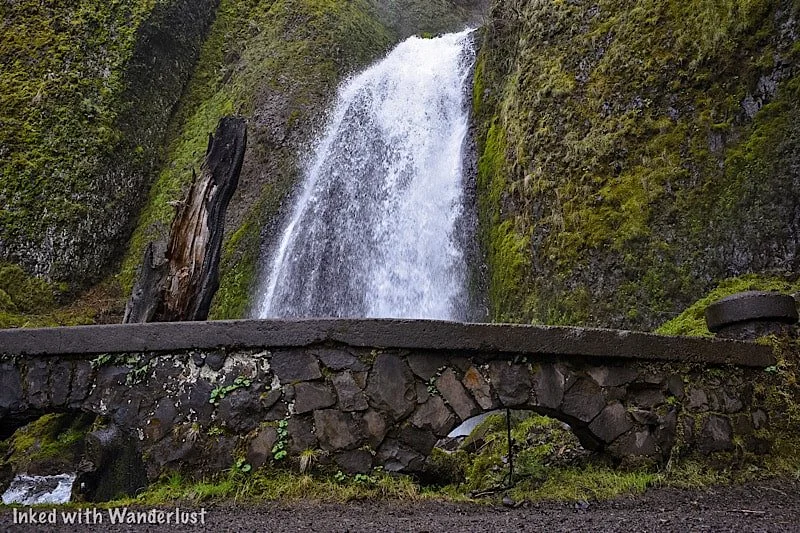
Located in the awe-inspiring Columbia River Gorge right off of the Historic Highway is the beautiful, easily accessed 120-foot waterfall, ‘Bridal Veil Falls’.
It’s part of the Oregon State Scenic Viewpoint and is on the site of an old lumber mill. The park is open year round and there are no entry or parking fees.
*If you’re visiting between May and September, you’ll need a vehicle permit to enter the Waterfall Corridor.
We were fortunate enough to discover this waterfall during our visit in March 2022. We learned quickly that Multnomah Falls wasn’t the only amazing waterfall around here.
In fact, there are MANY gorgeous waterfalls on the Oregon AND Washington side of the river. This post, though, will focus on Bridal Veil.
So are the trails difficult or easy? What can you expect once you reach the falls? How do you get there? We’ll answer these questions and more below!
Here’s some gear we recommend…
Getting To Bridal Veil Falls and Permits
Getting There
Bridal Veil Falls can be found along Oregon’s Waterfall Corridor inside the Columbia River Gorge. It’s super easy to find as its parking lot is right off the highway.
The exact address is E Crown Point HWY, Bridal Veil, OR 97010. Simply plugging, ‘Bridal Veil Falls’, into your GPS will suffice.
From Vista House: Leaving the Vista House lot, drive east on Historic Columbia River Highway for 4.5 miles. It’ll be the next waterfall AFTER Latourell Falls and the parking lot will be on your left (across from the Lodge).
From Cascade Locks: Travel west on Interstate 84. Take exit 35 to the Historic Columbia River Highway. It’ll be the next waterfall after Wahkeena Falls and the parking lot will be on your right. Total milage is around 18 miles.
From Portland: Make your way to Interstate 84 east and stay on it for about 25 miles. You’ll take exit #28 (look for signs stating Bridal Veil and/or Angel’s Rest) and follow the signs for the Historic Highway. The parking lot will be on your right.

You’ll know you’ve arrived to the correct lot (aside from the signage) when you see Bridal Veil Falls Lodge across the street.
The park is located in between two equally beautiful waterfalls, Latourell Falls and Wahkeena Falls. Unlike them, though, Bridal Veil is on the north side of the highway.
Fees
There are no fees for Bridal Veil Falls, but if your visit coincides with the May through September timeframe, you will need a permit to access the Historic Highway.
The fee for this permit is $2 per vehicle and they will be verified by State Parks Staff between Bridal Veil (near exit 28) and Ainsworth State Park.
Trails to Bridal Veil Falls
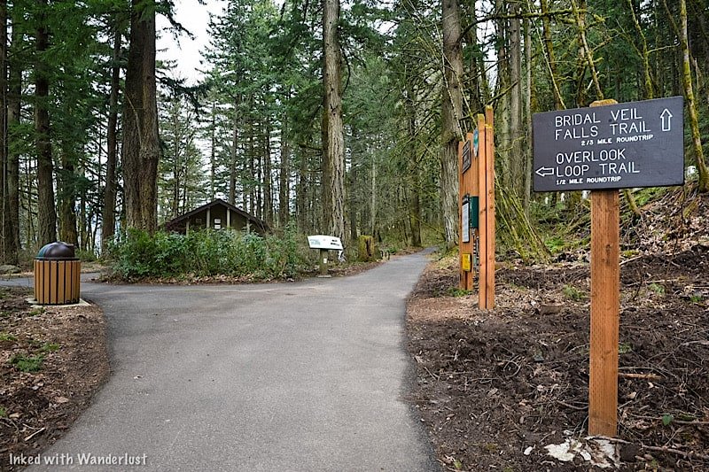
Overlook Loop Trail
On arrival, you’ll have a choice to make. You can go straight on the traditional Bridal Veil Falls trail or you can bear left to the overlook.
Initially, we had every intention of doing both (they are not connected). We were going to do the main trail, come back, and then go to the overlook.
However, we spent more time than we thought we would down there and by the time we got back to the split, we had run out of time.
We had dinner reservations in downtown Portland and if we didn’t leave at that moment, we would’ve missed it. So we had to bank it for next time.
Based on pictures we’ve seen, the trail is half a mile (roundtrip) and terminates at a wooded platform overlooking the top of the falls (similar to the one we went to).
*At the split (just off from the parking lot) you’ll find a restroom open to public use
Bridal Veil Falls Trail
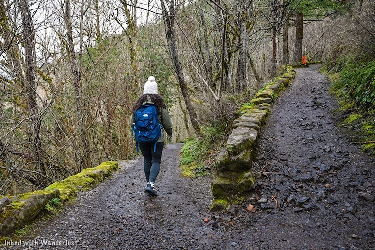
The main trail to the base of falls is 3/4’s of a mile (roundtrip) on a slightly steep decent to Bridal Veil Creek and the falls.
It had just rained during our visit so the trail was a little muddy, but we had no problem navigating it. We would rate it as easy going down and easy to moderate going up.

Soon after the second switchback is when you’ll run into the first of two bridges on the trail. This bridge is followed by a concrete stairwell leading you to the next bridge.
The second bridge takes you across Bridal Veil Creek and leads you to yet another stairwell, this one taking you up to a wooded viewing deck for the waterfall.

Take the stairwell to the viewing deck overlooking Bridal Veil Falls. The deck isn’t big so if it’s busy, you’ll have to hang out for a few minutes until a spot opens.
There are many different perspectives of the waterfall from here. If you’re into photography, you can get pretty creative here.


When you’re done, simply head back in the direction you came to the trailhead. From there, you can leave or see the top of the falls from the Overlook Loop.
Additional Things To Know
It is visible from the road, but don’t do it. That road is very narrow and the chance of a vehicle vs. pedestrian accident occurring is high. View the falls from one (or both) of the trails, not the road.
Drone use is prohibited. Like most of the gorge, drone use is not allowed at Bridal Veil.
No EV charging stations. The nearest ones are to the west of Bridal Veil in Troutdale.
Restroom is available. There is a restroom (vault variety) just ahead of the trail split near the parking lot.

Nearby Attractions
This area is littered with amazing natural sights, most of which require little to no effort to see (aside from driving around).
There’s so many that we couldn’t possibly list them all, but we will list a few of our favorites. If you’d like to see more, check out the website, Ready Set Gorge.
Multnomah Falls - The tallest waterfall in Oregon and one of the most visited natural sites in the PNW. Check out our guide by tapping/clicking on the link.
Vista House (Crown Point)
Wahkeena Falls
Oneonta Gorge (currently closed)
Bridge of the Gods (connects Oregon and Washington)
Latourell Falls
Ainsworth State Park
Horsetail Falls
Fairy Falls
Angel’s Rest (hiking trail)
And so much more!
A Quick Note…
We’re often asked about the equipment we use to capture the photos on our website. Below, we’ve added Amazon links to those products and others that we recommend.
If you decide to purchase, Amazon will pay us a small commission. This helps us keep Inked with Wanderlust running and doesn’t cost you anything extra.
“Understanding Exposure” by Bryan Peterson (this book is a great resource for anyone starting out in photography)
It is our hope that this article was helpful to you in planning your next adventure. If so, please share it with your family and friends on Facebook or Pinterest.
You can further show support by subscribing to our newsletter below. In it, you’ll receive a once weekly newsletter containing announcements, new post alerts, news, and more!
If you have any questions, comments, or suggestions, please engage with us in the comment section below.
Thanks for reading and safe travels!

How To Hike To Witches Castle (Stone House) in Portland
When we were planning our trip to Portland, we found many attractions we wanted to check out. Witches Castle, however, was…
Disclosure: This post contains affiliate links. If you make a purchase through these links, I may earn a small commission at no additional cost to you. I only recommend products or services that I believe will add value to my readers.
When we were planning our trip to Portland, we found many attractions we wanted to check out. Witches Castle, however, was near the top of the list. Officially called “Stone House”, it was given the name “Witches Castle” by a group of local teenagers many years ago and the nickname stuck.
You can find it in Macleay Park, which itself is located within the much larger Forest Park. All of this is just a mere few miles from downtown Portland, making it an easy way to escape the hustle and bustle of the city.
In this guide, I’ll discuss how to get to the trailhead, trail details, the history of Witch’s Castle, parking details and much more. Let’s get into it!
Getting To Witches Castle and Parking

You can find the castle by hiking the Wildwood Trail. It can be accessed by both Upper and Lower Macleay Park. Lower Macleay Park is located at the corner of NW 30th and Upshur, just outside of a residential neighborhood.
The parking lot is fairly large, but I can see it filling up quickly in the summer months, so plan accordingly. To reach Witches Castle from here, take the smooth, flat trail for 3/4’s of a mile. From what we were told, it is relatively flat and smooth.

You can find the upper parking lot just passed the Portland Audubon Society. You’ll see a sign (pictured above) indicating you’re in the right spot. The parking lot can hold a decent amount of vehicles but like the lower lot, it will probably fill quickly during summer time.
There’s a single, portable bathroom and off in the grassy area you’ll find a couple picnic tables. The trail starts where the parking lot ends.
Transportation To The Park
Public Buses: Buses run from the downtown area and throughout Forest Park with multiple stops. For detailed information on, follow this link.
Vehicle: If you have your own vehicle, simply punch “Upper Macleay Park” (or Lower) into your GPS of choice and follow the directions.
Uber/Lyft: Cell reception is good here, so utilizing ride-sharing options is an option (it’s what we did). Just be sure to specify Macleay Park as your drop-off location and not, “Witches Castle”.
The Wildwood Trail (Upper)

From the parking lot to Witches Castle it’s a half-mile, downhill hike up until you reach the bridge. After the bridge, it’s easy going with only minor, barely noticeable inclines and declines.
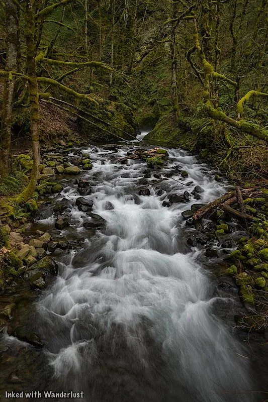
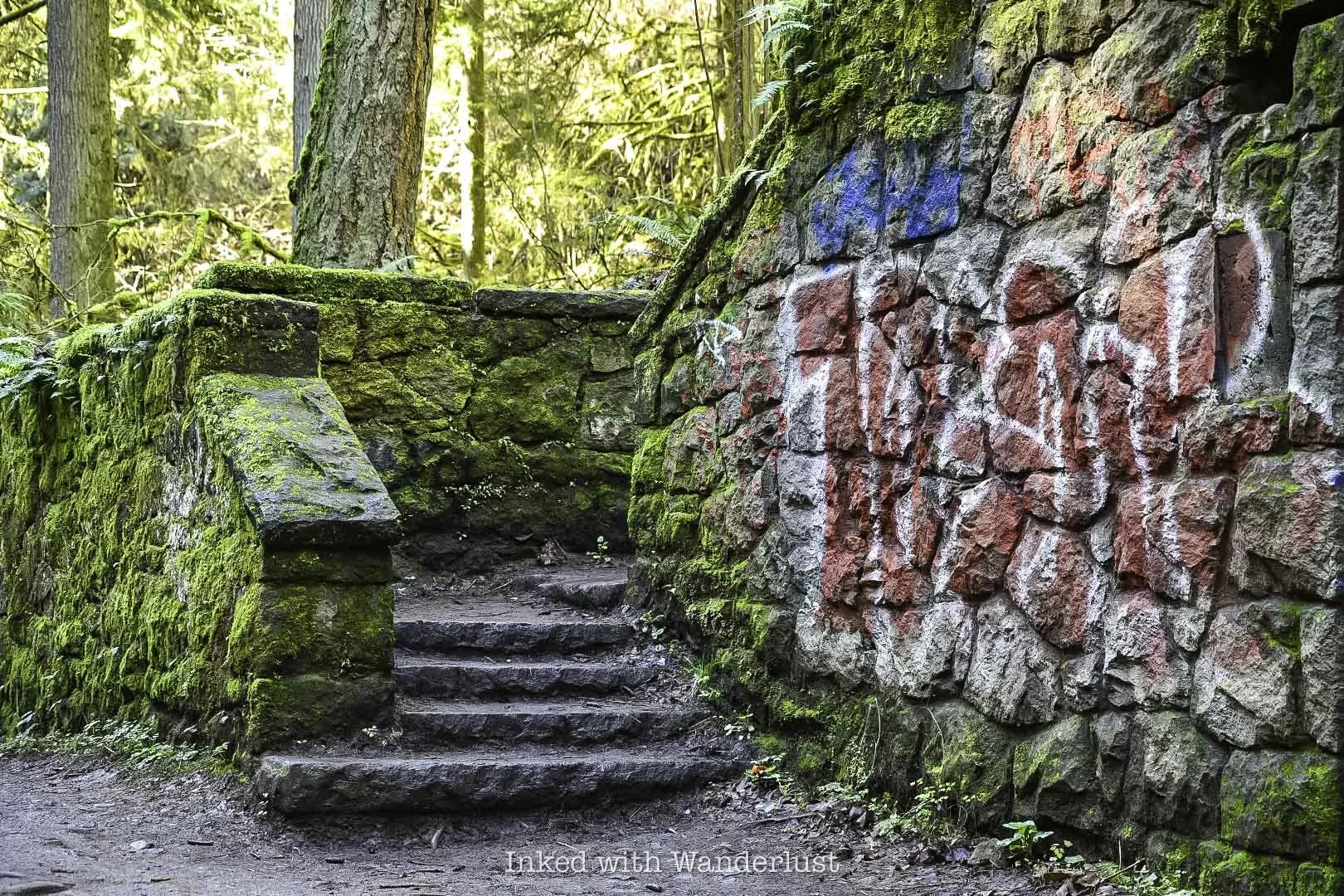
From the parking lot, you’ll head left on the trail. You’ll almost immediately begin your downhill descent through beautiful moss covered trees and rocks. As you descend, you’ll begin to hear the sounds of rushing water. That’s because there’s a beautiful creek running parallel to the trail at the bottom.
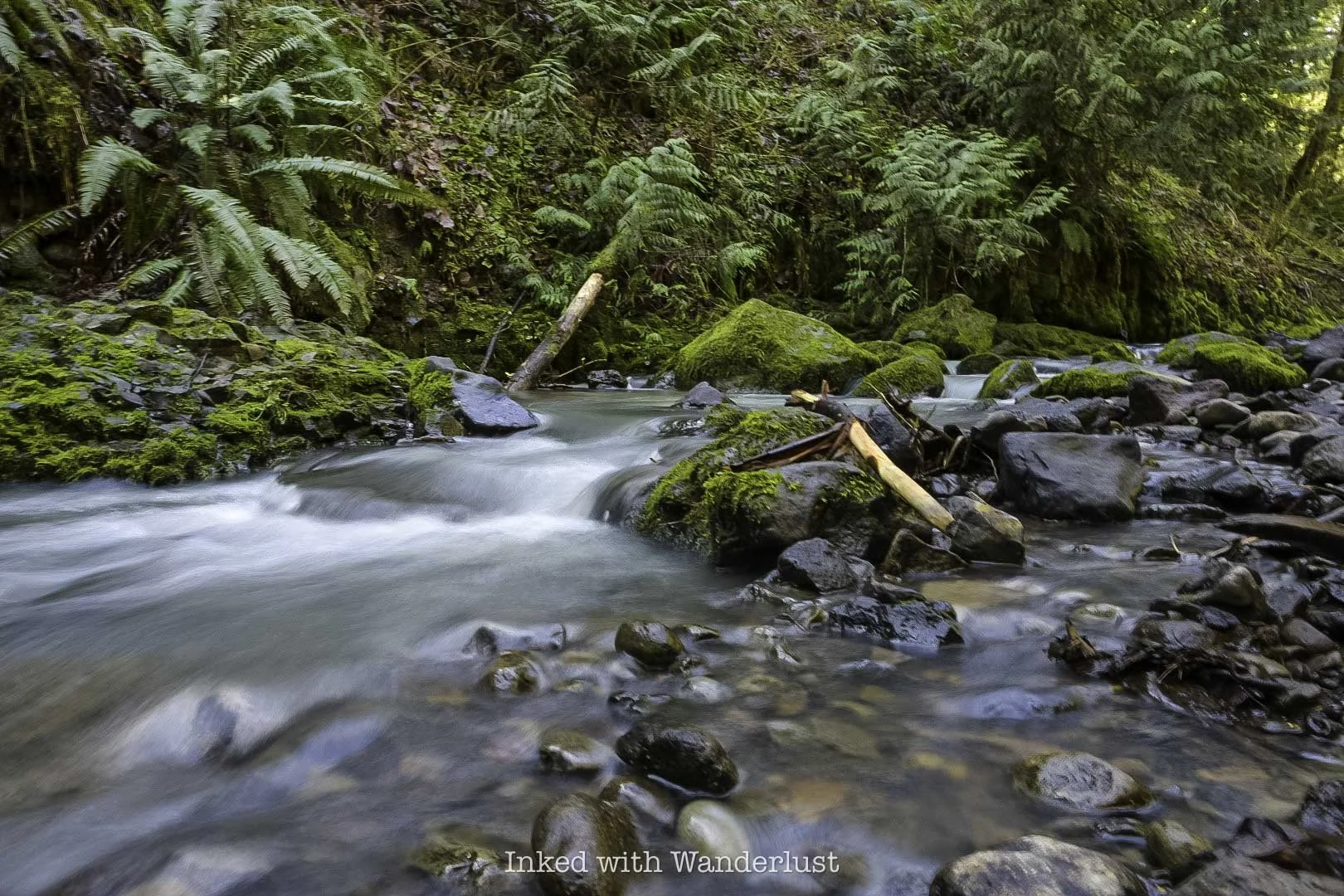
In a short time, the bridge will come into view. This bridge gets you across the creek and provides an epic view of a beautiful cascade as you cross.
Be sure to spend time here taking all the pictures you can. To me, it was just as much a highlight as Witches Castle. From here, you’re about halfway to the castle. The trail will mostly flatten out with only a few, hardly noticeable elevation changes.
On the way to the castle, you’ll be treated to non-stop views of multiple cascades running through moss covered rocks and downed branches. It’s like stepping into a fairytale novel (similar to Mossbrea Falls in California).
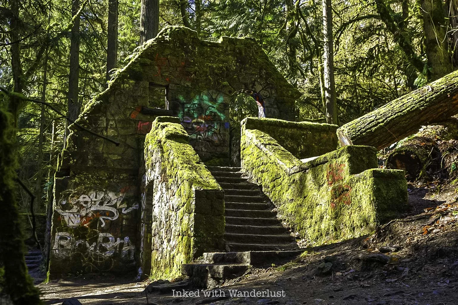
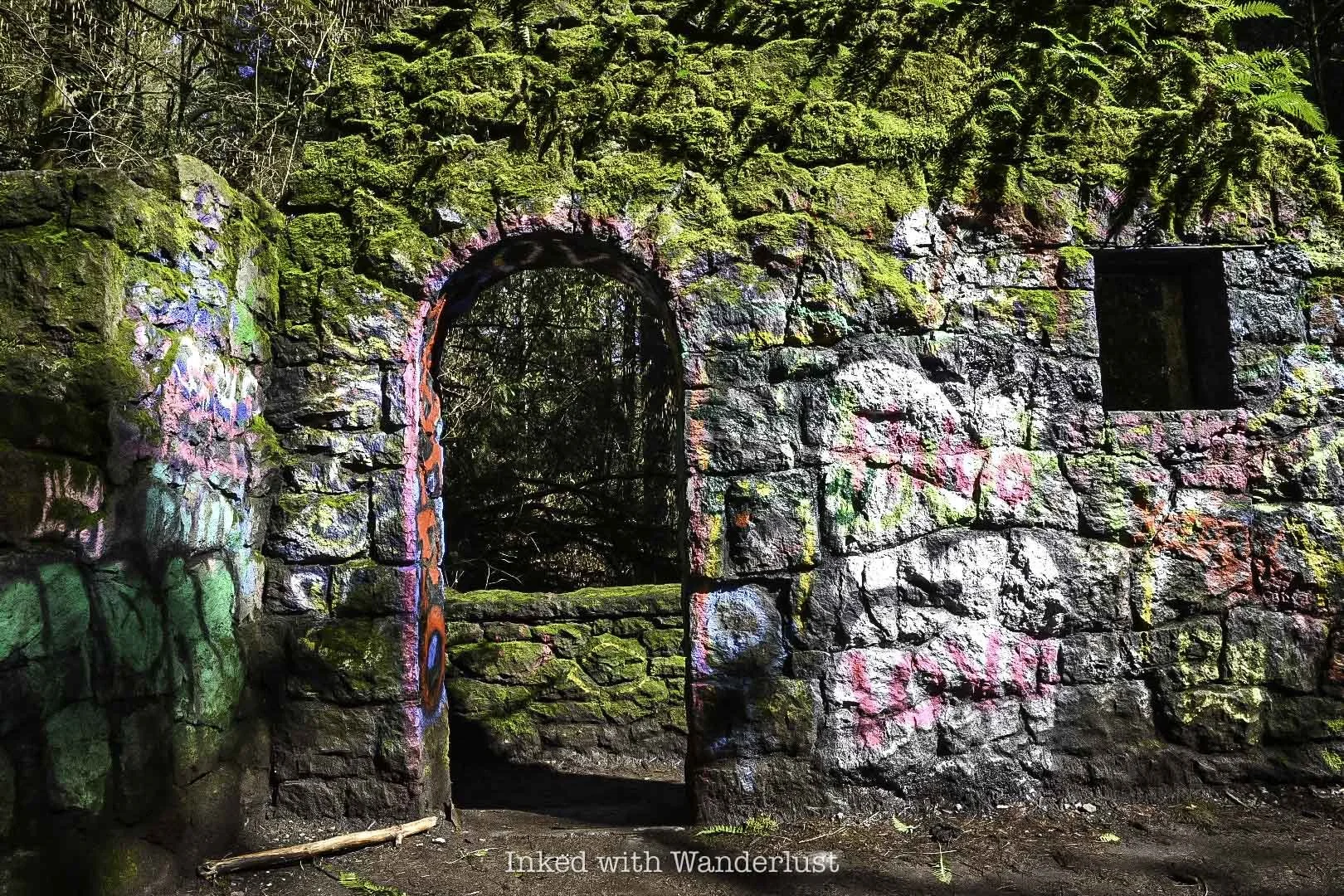
Witches Castle

Before you’ll know it, you’ll arrive at Witches Castle at around the quarter-mile mark (from the bridge). It kinda sneaks up on you through the trees. As you can see in the photo above, this is a popular place for taggers (graffiti). Every so often the city will clean it off but that’s happening less and less now.
When we were here (early March) we only had to share the space with a few others. If you come in the summer, though, prepare yourself for crowds. No matter when you decide to hike to Witches Castle, do it early for a near crowd-free experience.
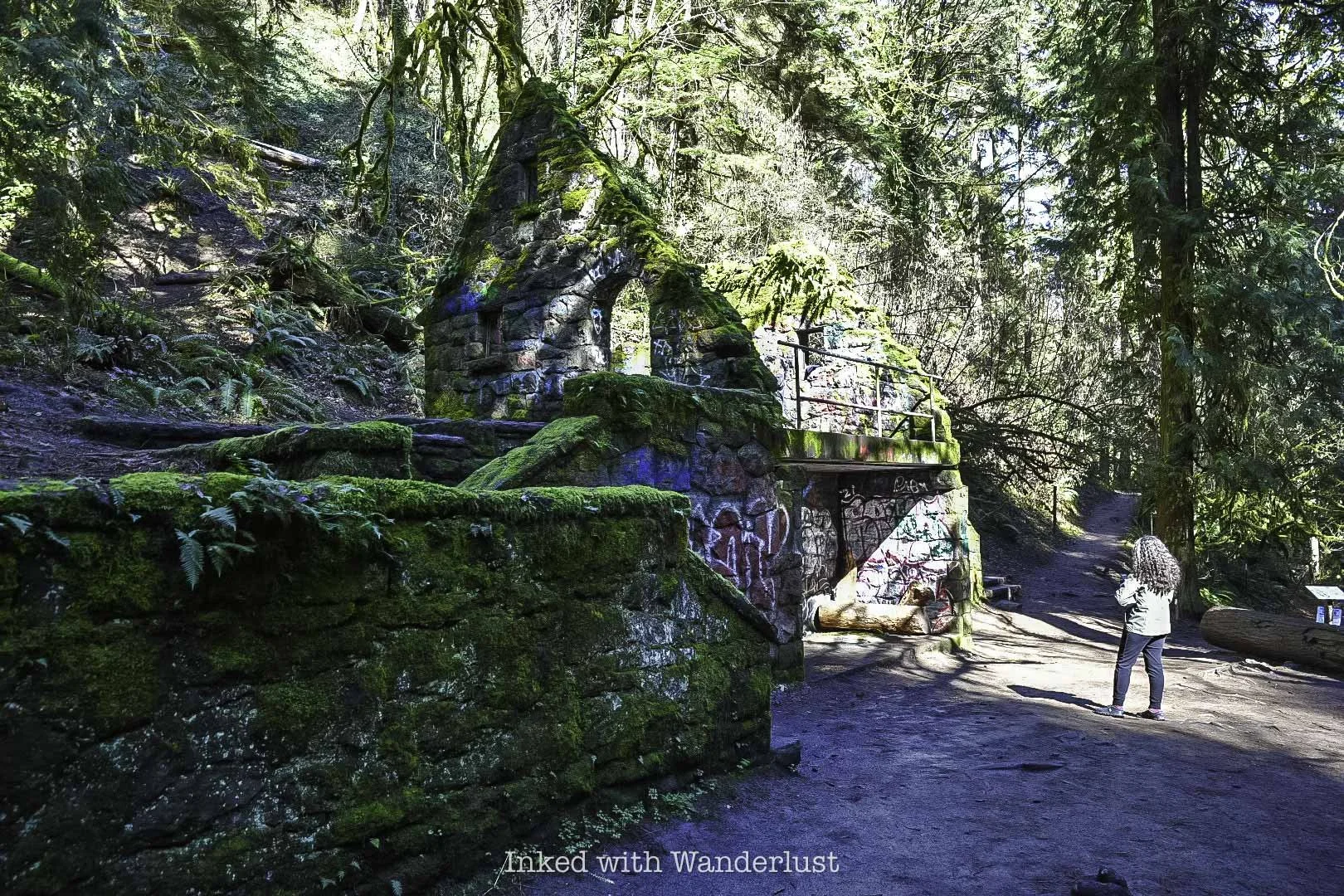
For being nearly one hundred years old, there’s a shockingly large amount of the structure remaining. There are two sets of stairs on each side, both leading to the main area of Witches Castle, which is open to the elements.
The castle is a hot spot for graffiti artists, much like another favorite spot of mine, the historic Donner Tunnels, in California. I’m not generally a fan of graffiti but much like the tunnels, it compliments and elevates the experience, instead of souring it.
Much like the graffiti, moss dominates the stone walls of the castle, providing a pleasant and photographically wonderful color contrast. You’re free to go up the stairs and explore the structure. Just be aware that there will likely be others trying to get their own pictures as well.
Once you’re done exploring the castle, either head back the way you came or keep hiking onward. Less than a mile hike from Witches Castle is the historically significant Pittock Mansion. Be sure to take a self-guided tour of the beautiful grounds and mansion.
Witches Castle History
By now, you’re probably dying to know how Witches Castle got its name and its backstory. It’s an age-old tale of romance, murder, and hauntings! Let’s get into it!
A Story of Love…and a Bullet
Danford Balch, who came to Oregon in 1850 with his family, claimed a large parcel of land in what is now Forest Park. He hired Mortimer Stump, a local man, to clean up the property and build a home.
When the home was finished, Mortimer moved in with the Balch family (this included Balch, his wife, and nine children). Eventually, Mortimer and Balch’s eldest daughter, Anna, would fall in love.
Their relationship would continue and eventually, Mortimer asked Balch for his blessing to marry Anna. I’ll give you one guess as to what his answer was…an emphatic “no!”
Balch felt that Mortimer wasn’t worthy of Anna and to drive his point home, he threatened to kill Mortimer if they ever eloped. Did that stop them? This wouldn’t be much of a story if it did, would it?

Long story short, they eloped in Vancouver in 1858 and came back shortly after to collect their belongings. Balch was waiting and would make good on his threat. He shot Mortimer dead…on sight.
Balch tried to make excuses for this but in the end, the police weren’t buying it. He was sentenced to death and hanged for his crime (which was the first legal hanging in Oregon, by the way).
Balch’s wife (who is often referred to as the “witch” in this story) stayed in the home and lived there until her death. Local lore says the spirits of Mortimer and Balch continue to haunt the property to this day.
The Stone House

When it comes to the actual structure we have today, well, it was never a home. The home that the Balch family lived in was demolished years ago. The stone structure, what we refer to as, ‘Witches Castle’, was built in 1930 and maintained by Portland Parks & Recreation. Originally, it was supposed to be a restroom and ranger station.
However, in 1962, a big storm came through and heavily damaged the structure. So much so, it was deemed useless and left abandoned. In the 1980’s, a group of local high school students re-discovered it and dubbed it, ‘The Witches Castle”. The rest, as they say, is history.
Things To Know Before Going
Park hours are between 5:00am and 10:00pm.
Dogs are permitted on the trail but you must pick up after them.
Much like other popular areas, vehicle break-ins are common here. We saw multiple piles of glass on the ground in the parking lot.
This trail is UBER popular. It was quiet when we were here, but it isn’t uncommon to see 150+ other hikers (or more) on this trail.
If you’re staying in downtown Portland and are looking for more weird Portland things to do, see 21 of them here! Also, for delicious Italian food, consider dinner at Gilda’s!