How To See Bridal Veil Falls In Oregon
6 minute read | Contains affiliate links
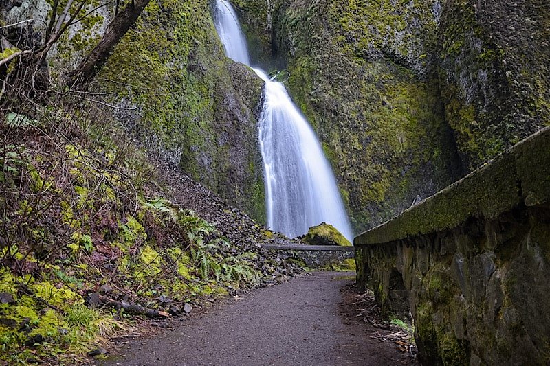
Located in the awe-inspiring Columbia River Gorge right off of the Historic Highway is the beautiful, easily accessed 120-foot waterfall, ‘Bridal Veil Falls’.
It’s part of the Oregon State Scenic Viewpoint and is on the site of an old lumber mill. The park is open year round and there are no entry or parking fees.
*If you’re visiting between May and September, you’ll need a vehicle permit to enter the Waterfall Corridor.
We were fortunate enough to discover this waterfall during our visit in March 2022. We learned quickly that Multnomah Falls wasn’t the only amazing waterfall around here.
In fact, there are MANY gorgeous waterfalls on the Oregon AND Washington side of the river. This post, though, will focus on Bridal Veil.
So are the trails difficult or easy? What can you expect once you reach the falls? How do you get there? We’ll answer these questions and more below!
Here’s some gear we recommend…
Getting To Bridal Veil Falls and Permits
Getting There
Bridal Veil Falls can be found along Oregon’s Waterfall Corridor inside the Columbia River Gorge. It’s super easy to find as its parking lot is right off the highway.
The exact address is E Crown Point HWY, Bridal Veil, OR 97010. Simply plugging, ‘Bridal Veil Falls’, into your GPS will suffice.
From Vista House: Leaving the Vista House lot, drive east on Historic Columbia River Highway for 4.5 miles. It’ll be the next waterfall AFTER Latourell Falls and the parking lot will be on your left (across from the Lodge).
From Cascade Locks: Travel west on Interstate 84. Take exit 35 to the Historic Columbia River Highway. It’ll be the next waterfall after Wahkeena Falls and the parking lot will be on your right. Total milage is around 18 miles.
From Portland: Make your way to Interstate 84 east and stay on it for about 25 miles. You’ll take exit #28 (look for signs stating Bridal Veil and/or Angel’s Rest) and follow the signs for the Historic Highway. The parking lot will be on your right.

You’ll know you’ve arrived to the correct lot (aside from the signage) when you see Bridal Veil Falls Lodge across the street.
The park is located in between two equally beautiful waterfalls, Latourell Falls and Wahkeena Falls. Unlike them, though, Bridal Veil is on the north side of the highway.
Fees
There are no fees for Bridal Veil Falls, but if your visit coincides with the May through September timeframe, you will need a permit to access the Historic Highway.
The fee for this permit is $2 per vehicle and they will be verified by State Parks Staff between Bridal Veil (near exit 28) and Ainsworth State Park.
Trails to Bridal Veil Falls
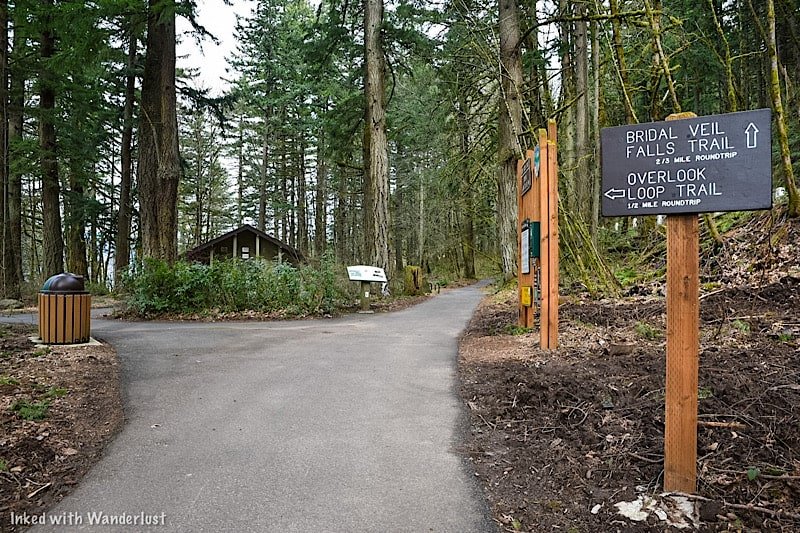
Overlook Loop Trail
On arrival, you’ll have a choice to make. You can go straight on the traditional Bridal Veil Falls trail or you can bear left to the overlook.
Initially, we had every intention of doing both (they are not connected). We were going to do the main trail, come back, and then go to the overlook.
However, we spent more time than we thought we would down there and by the time we got back to the split, we had run out of time.
We had dinner reservations in downtown Portland and if we didn’t leave at that moment, we would’ve missed it. So we had to bank it for next time.
Based on pictures we’ve seen, the trail is half a mile (roundtrip) and terminates at a wooded platform overlooking the top of the falls (similar to the one we went to).
*At the split (just off from the parking lot) you’ll find a restroom open to public use
Bridal Veil Falls Trail
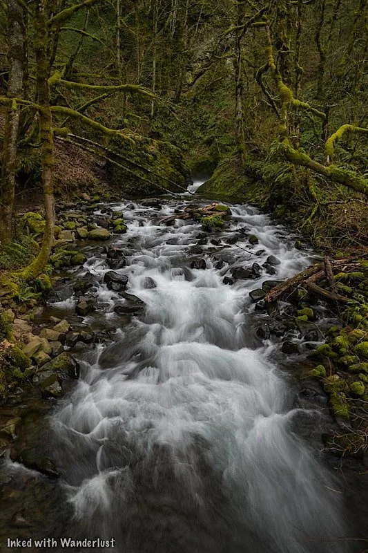
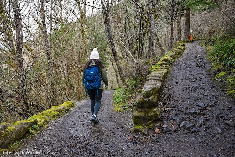
The main trail to the base of falls is 3/4’s of a mile (roundtrip) on a slightly steep decent to Bridal Veil Creek and the falls.
It had just rained during our visit so the trail was a little muddy, but we had no problem navigating it. We would rate it as easy going down and easy to moderate going up.

Soon after the second switchback is when you’ll run into the first of two bridges on the trail. This bridge is followed by a concrete stairwell leading you to the next bridge.
The second bridge takes you across Bridal Veil Creek and leads you to yet another stairwell, this one taking you up to a wooded viewing deck for the waterfall.

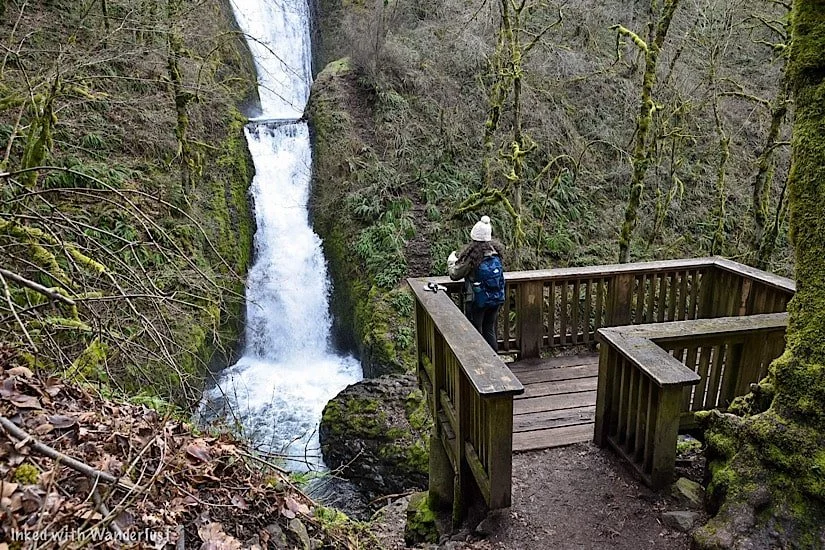
Take the stairwell to the viewing deck overlooking Bridal Veil Falls. The deck isn’t big so if it’s busy, you’ll have to hang out for a few minutes until a spot opens.
There are many different perspectives of the waterfall from here. If you’re into photography, you can get pretty creative here.


When you’re done, simply head back in the direction you came to the trailhead. From there, you can leave or see the top of the falls from the Overlook Loop.
Additional Things To Know
It is visible from the road, but don’t do it. That road is very narrow and the chance of a vehicle vs. pedestrian accident occurring is high. View the falls from one (or both) of the trails, not the road.
Drone use is prohibited. Like most of the gorge, drone use is not allowed at Bridal Veil.
No EV charging stations. The nearest ones are to the west of Bridal Veil in Troutdale.
Restroom is available. There is a restroom (vault variety) just ahead of the trail split near the parking lot.

Nearby Attractions
This area is littered with amazing natural sights, most of which require little to no effort to see (aside from driving around).
There’s so many that we couldn’t possibly list them all, but we will list a few of our favorites. If you’d like to see more, check out the website, Ready Set Gorge.
Multnomah Falls - The tallest waterfall in Oregon and one of the most visited natural sites in the PNW. Check out our guide by tapping/clicking on the link.
Vista House (Crown Point)
Wahkeena Falls
Oneonta Gorge (currently closed)
Bridge of the Gods (connects Oregon and Washington)
Latourell Falls
Ainsworth State Park
Horsetail Falls
Fairy Falls
Angel’s Rest (hiking trail)
And so much more!
A Quick Note…
We’re often asked about the equipment we use to capture the photos on our website. Below, we’ve added Amazon links to those products and others that we recommend.
If you decide to purchase, Amazon will pay us a small commission. This helps us keep Inked with Wanderlust running and doesn’t cost you anything extra.
“Understanding Exposure” by Bryan Peterson (this book is a great resource for anyone starting out in photography)


It is our hope that this article was helpful to you in planning your next adventure. If so, please share it with your family and friends on Facebook or Pinterest.
You can further show support by subscribing to our newsletter below. In it, you’ll receive a once weekly newsletter containing announcements, new post alerts, news, and more!
If you have any questions, comments, or suggestions, please engage with us in the comment section below.
Thanks for reading and safe travels!