Hike To Eagle Falls and Eagle Lake In Lake Tahoe
6 minute read | contains affiliate links
Lake Tahoe is filled to the brim with hiking trails of varying lengths. Some can be done in a matter of hours while some will take a day or two to complete.
If you’re new to hiking - or you’re a family with children in tow - you may be wondering which Tahoe trails would be best for you. Enter, Eagle Lake.
It’s a short, albeit rocky trail that begins at a beautiful waterfall (Eagle Falls) and concludes at the equally beautiful sub-alpine lake surrounded by rocky granite mountains.
In this guide, we’ll cover everything you’ll need to know about this trail, including; how to get there, what to expect, pictures and more! Let’s get into it!
Here’s some great hiking equipment we recommend…
Quick Stats
Location: Emerald Bay State Park, Lake Tahoe
Fee/Permit: $10 per vehicle parking fee
Open: Year round (though the road to Emerald Bay does close in the winter if conditions are bad
For: Hikers
Parking: Small, paved lot at the trailhead and another (even smaller) lot along the road
Restroom: Yes. At the trailhead
EV Stations: None
Drone Use: Not allowed
Difficulty: Easy to moderate
Popularity: High
Time: 2-3 hours
Milage: 1.9-miles, round-trip
Elevation Gain: 459-feet
Trail Condition: Maintained and clearly signed
Main Feature(s): Waterfall and lake
Pets: Allowed on leash
Special Notes/Hazards: This trail is VERY rocky.
Our Visit(s): 2016, 2018, & 2022
Location & Parking

While not contained within Emerald Bay State Park proper, the parking lot and trailhead can be found just outside its bounderies across the road.
From South Lake Tahoe:
Head south on Lake Tahoe blvd for 2.5 to 3-miles (depending on where you are in South Lake).
Turn right onto CA-89 north/Emerald Bay road.
You’ll soon hit a series of switchbacks and before long, you’ll arrive in Emerald Bay.
Don’t turn right in the lot when you see the sign for Emerald Bay. That’s for the campground.
Instead, continue straight until you see the sign for Eagle Falls (pictured above) and turn left into the parking lot.
From North Lake Tahoe:
Make your way to CA-89 south and stay on it for about 18-miles.
You’ll pass D.L. Bliss State Park before arriving.
After entering Emerald Bay, turn right into the parking lot at the Eagle Falls sign.
Parking is going to be the hardest part of this whole experience. For starters, the lot fills QUICKLY during the spring and summer months.
If you arrive before 9am, you’ll probably be ok. Any time after that, though, and you’ll have a rough time. It may be necessary to circle around a couple of times.
If the lot at the trailhead is full, there’s a small pull-out style lot along the road you can use. Every time we’ve gone, this was where we ended up parking.
The biggest advantage to parking here is you don’t have to pay the parking fee. If you park in the main lot, then you’ll need to pay the $10 per vehicle fee.
Lower Eagle Falls

One aspect of this hike people tend to miss is the lower section of Eagle Falls. To get to it, you’ll need to (safely) cross the road from the parking lot.
You won’t get the traditional, straight-on view of the falls, but you will have the opportunity to get close to it. Especially when the run-off starts to slow down.

From the lower falls, you’ll also get an awesome view of Emerald Bay and Fannette Island. You’ll be contending with trees slightly obstructing your view, though.

When you’re done taking in the views, simply head back up to the road and cross it to get back over to the Eagle Falls trailhead.
If you’re facing the lot, use the boardwalk style walkway on your left. This is a much safer route to the trailhead versus walking through the lot and dodging vehicles.
Upper Eagle Falls

The tail to Eagle Lake officially begins near the upper portion of Eagle Falls. From the trailhead to the bridge at the upper falls, it’s about a quarter-mile.
The trail immediately begins to climb from the trailhead up wide steps made from rock and wooden pillars. You’ll get a temporary reprieve at the top.

As the trail levels out, you’ll come to a junction. Going right will take you to an elevated viewing area for Eagle Falls. Going straight will take you to the bridge.
Shortly after the junction, the bridge will come into view. To the right of it, there’s a bench you can use to rest if needed.


To the left of the bench you’ll find a small viewing area that provides a full view of the upper falls with the bridge in the backdrop.
You will need to scramble down to it and it’s a bit sketchy. Taking small children down there probably wouldn’t be the best idea.

After crossing the bridge, you’ll see a small opening on your right between a few boulders and bushes. If you go through it, it’ll take you to the pond above Eagle Falls.


There wasn’t any signage stating to keep out but I would advise against against it considering it’s literally RIGHT above the crest of the falls.
To continue onto Eagle Lake, simply get back onto the trail and head up. From here, the trail gets even rockier. So watch your footing.
Trail To Eagle Lake

From this point forward, you’ll be in Tahoe’s Desolation Wilderness. In order to pass this point, you will have needed to fill out a permit at the trailhead.
The permit doesn’t cost anything. This is just their way of keeping track of how many people are in Desolation and in case anyone goes missing, they’ll have an idea where you are.
Simply fill out the permit at the trailhead and drop it into the iron ranger. This rule was suspended during the 2022 season but it’ll probably kick back up again in 2023.
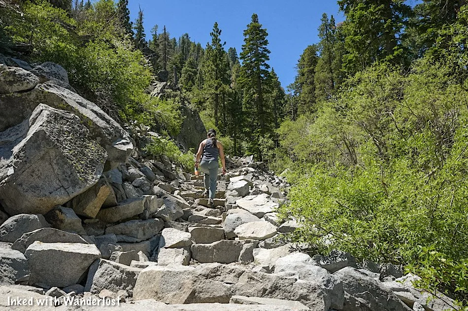
From here, the trail gets even rockier than how it was before. It’s literally carved out of rock in most places. Being mindful of your footing is paramount. Many of the rocks are slick.
You’ll continue this incline for another quarter-mile or so before it flattens out up top for a temporary reprieve. From here, you’ll be treated to an epic view of Emerald Bay and the lake.

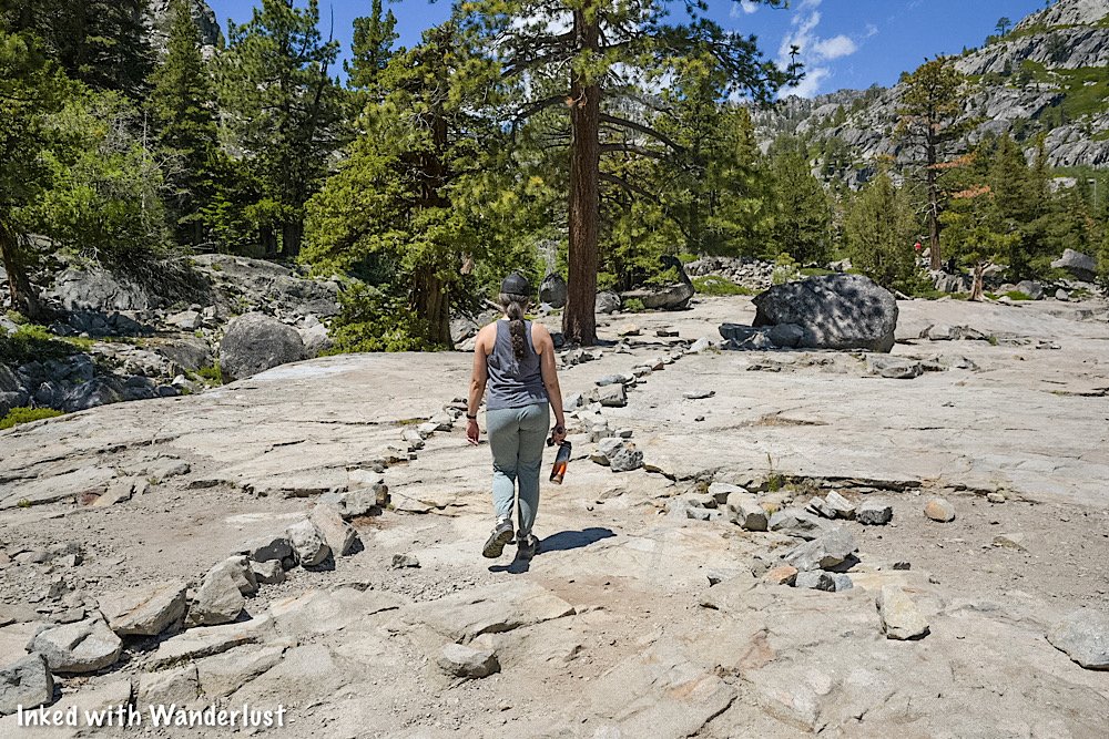
This middle section of the trail crosses over straight granite, making the trail a bit easy to lose at times. Follow the rocks lining the path and keep to the left.
If you want to see the view of Lake Tahoe as pictured above, you will need to leave the official trail a bit to see it.

Also coming into view throughout this section are the craggy peaks surrounding Eagle Falls and Eagle Lake. The scenery is simply stunning.
Before long, the trail will begin to ascend again as you make the final push to Eagle Lake. The sounds of the creek in the ravine below signals how close you’re getting.

The incline levels out a bit as the peak above Eagle Lake comes into view. You’ll pass another junction at this point. Keep straight.
Soon after this junction, you’ll come to Eagle Lake. Most people stop at the rocky beach near the outlet of the lake. For more privacy, continue straight to other spots.
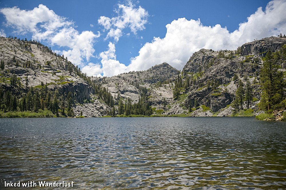
Eagle Lake

As stated above, this small rocky beach is where most people stop. The outlet is right there and is lined with stepping stones to afford you access to the other side.
You can continue straight for other beaches with less crowds, but these aren’t very well maintained. So you’ll be fighting fallen branches and other hazards.


Eagle Lake sits at around 6,000-feet and is surrounded by rocky, granite peaks. It gets its water from snow melt run-off in the mountains.
The lake itself, while cold, is perfect for swimming or wading. We would recommend keeping kids away from the outlet of the lake, though.


From here, you have a couple choices. The first is you just head back the same way you came to the trailhead.
If you have enough energy, though, you can continue up the trail to more alpine lakes including Granite Lake, Dick’s Lake and Velma Lake.
This short-but-sweet hike to Eagle Falls and Eagle Lake is nothing short of spectacular. It packs a lot of punch with little effort required.
Your Thoughts…
Does this seems like a trail you and your family would enjoy? Tell us about it in the comment section below. We love hearing from our readers!


Please support our website by sharing it with your family and friends.
Thank you for reading.