Hike The Waterfall Trail In Grover Hot Springs State Park
3 minute read | contains affiliate links
Nestled within a quiet corner of the eastern Sierra Nevada mountains lies an underrated, little-known gem in the California state park system; Grover Hot Springs.
Grover doesn’t have the same notoriety as Yosemite or even nearby Lake Tahoe, but that’s where it gets its charm. It isn’t dense in crowds, so it’s incredibly easy to spend a serene day (or two) in its pristine setting.
In 2021, the park was shuttered due to damage sustained by the Tamarack Fire. Many trees and other shrubbery were charred, in addition to the parks infrastructure (including the hot springs complex).
Thanks to the efforts of park staff, the park’s campground and hiking trails reopened in time for the 2022 summer season. The hot springs, unfortunately, did not reopen and remain closed at the time of this writing.
In June 2023, I returned to the park to hike the Waterfall Trail. It’s a short and sweet hike terminating at an incredible 50-foot waterfall with multiple cascades.
The trail is perfect for families as there’s little elevation gain, it’s easy to follow and you’re treated to an amazing award with little effort required. Additionally, your furry, four-legged kids can join you.
So how do you get there? How many miles are involved? Is parking available? I answer all these questions and more below. Let’s get into it!

Exciting news for our readers!
We’re excited to introduce the all-new "Inked with Wanderlust" online store!
We're thrilled to bring you a fantastic collection of wanderlust-inspired merchandise. Celebrate your love for travel and exploration with our stylish apparel and accessories, designed to ignite your sense of adventure.
Discover a range of unique designs that capture the spirit of wanderlust, from cozy hiking-themed t-shirts to charming accessories that make your wanderlust spirit soar!
Visit our online store today and start your journey of style and adventure. Happy exploring!

Trail Stats
Location: Grover Hot Springs State Park. Markleeville, CA
Fee: $8 day-use fee
Payment Type: Cash only. No digital pay stations
Open: Seasonally
For: Hikers
Restroom: In the campground and near the hot springs complex
Parking: Small lot near the campground, large lot near the hot springs (currently inaccessible)
EV Stations: None
Difficulty: Easy
Popularity: Medium to low
Mileage: 1.5 miles, one way
Time: 45 minutes to one hour
Elevation Gain: 90 feet
Condition: Maintained, but damaged from the Tamarack Fire
Features: 50-foot water, alpine meadows, craggy peaks
Pets: Allowed on leash
Drones: Not allowed
Hazards: Soft soil, downed trees and trees with potential to fall are still present. Additionally, this area sees heavy bear activity
My Visit(s): 2017, 2018 and 2023
Getting to Grover Hot Springs SP

As stated above, Grover is located in the beautiful eastern pocket of the Sierra Nevada mountain range so no matter which route you take, the drive is going to be scenic.
There are multiple routes to take depending on which direction you’re coming from:
Lake Tahoe: You’ll simply go south on CA-89
Sacramento: Travel east on US-50 and then south on CA-89
Bridgeport: Go north on US-395 and then north on CA-89
Reno: Head south of US-395/US-88, before going south on CA-89

My recommendation, unless you’re coming the opposite side, is to choose a route that traverses over Monitor Pass (pictured above). It’s a jaw-dropping, beautiful drive and my personal favorite.
Even if you’re coming from the opposite side, try to build driving through Monitor Pass into your travel plans. Trust me, it’s worth it.
Once you’re in Markleeville proper (you’ll pass numerous shops and restaurants), turn onto Montgomery street and continue straight until it terminates at Grover Hot Springs.
Grover Hot Springs Parking & Fees

Presently, there is only one option for parking at the park; near the campground (or in it if you’re camping). Assuming you’re just hiking, you’ll park in a small dirt lot with enough room to accommodate a dozen or so vehicles.
Once the hot springs reopens there’s a much larger lot you could utilize there. The trail to the waterfall can be accessed from either, though, and neither one is any longer than the other.
To use the hiking trail, you’ll need to pay an $8 day-use fee. There are no digital pay stations, so fees must be paid in cash via the yellow envelopes. Be sure to keep the receipt on your dash.
If you purchase a pass to the hot springs once they reopen, that pass includes the park’s day-use fee, FYI.
Where Does The Waterfall Trail Begin?

The trail goes by a few names but for all intents and purposes, I’ll refer to it as the, “Waterfall Trail”, in this post as it is the main (and only) trail in the park proper.
There’s a trailhead near the day-use parking lot by the campground and another just past the hot springs complex. They both eventually intersect.
I have taken both routes but in order to present the most current information, this post will focus on the trailhead near the campground.
The Waterfall Trail

The trail begins along an accessible wooden boardwalk through a beautiful alpine meadow. It’s one of the few areas of the park that wasn’t heavily affected by the fire.


Along the boardwalk, there are numerous informational boards detailing the park’s history and development as well as benches to relax and take in the scenery on.
It’s quick, though, as you’ll soon reach a cluster of pine trees where the boardwalk ends and becomes a gravel/dirt path.

You’ll soon approach the only un-jumpable stream crossing of the trail. At worst, it’s ankle deep and will undoubtedly evaporate as snow-melt eases.
Shortly after this stream crossing, you’ll come to a slight fork. Coming from the direction of the campground, you’ll want to continue straight towards the charred trees.

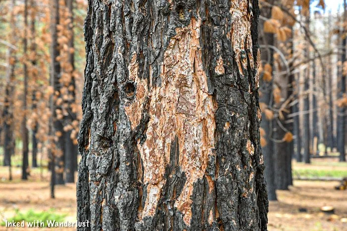
This will be your first real example of the damage done by the Tamarack Fire. Many trees remain standing, but just as many were reduced to ash and/or had to be downed.
On the forest floor, you’ll see greenery sprouting through, trying to breathe new life into the area. You can also see trees shedding charred bark.
You’ll get an up-close-and-personal look at not only the ugly, destructive side of a fire, but the beauty and new life it brings about as well.

Soon, the trail will align with the creek on your left and that’ll continue throughout the rest of your hike until you reach the waterfall.

Shortly after aligning with the river, you’ll come to another fork. Continuing straight will take you to the falls while going right will take to Burnside Lake (5-miles).
From here, you’re only half-a-mile away from the falls. However, you’ll first have to negotiate the one and only “adventurous” section of this trail; the boulder field.

Initially, the trail appears to vanish, but fret not. Simply look to your right and you’ll notice a trail heading up and into the boulder field in front of you.
Negotiating it isn’t difficult and doesn’t require any rock climbing know-how. A little bit of boulder hopping and common sense will get you through just fine.
I’ve always found that keeping to the left side of the boulder field offers the path of least resistance. However, any route you decide to go with will get you there.

Once you get to the other side of the boulders, you’ll get your first glimpse of the waterfall ahead of you. Actually, you’ll likely hear it long before you see it.
Continue straight and you’ll soon reach the waterfall.
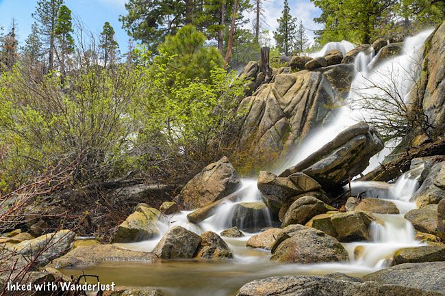

To view the falls from the base, you’ll need to break away from the trail proper and take a spur trail down. There isn’t a lot room down there so plan to arrive early if you want it to yourself.
If you continue further up the trail, you’ll get much closer the waterfall’s crest and have considerably more elbow room if you’re hear on a particularly busy day.


While this is the official conclusion of this portion of the trail, you can continue to explore further up and find more waterfalls.
If you’re not feeling up to it, though, spend as much time here as you please and when ready, go back the same way you came.
I hope you’ll consider hiking this trail. Whether solo, with a partner, or your family. I have no doubt you’ll love it as much as I do.
Travel safe, travel responsibly.
Check Out These Amazing Nearly Destinations!


Please support this website by subscribing to the newsletter below.
Thank you for reading.